
Dalton Gardens topographic map
Interactive map
Click on the map to display elevation.
About this map
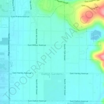
Name: Dalton Gardens topographic map, elevation, terrain.
Location: Dalton Gardens, Kootenai County, Idaho, United States (47.72246 -116.78678 47.74812 -116.74883)
Average elevation: 697 m
Minimum elevation: 675 m
Maximum elevation: 805 m
Other topographic maps
Click on a map to view its topography, its elevation and its terrain.
Coeur d'Alene
United States > Idaho > Kootenai County
Coeur d'Alene, Kootenai County, Idaho, 83815, United States
Average elevation: 719 m
Post Falls
United States > Idaho > Kootenai County
Post Falls, Kootenai County, Idaho, 83854, United States
Average elevation: 710 m
Hauser
United States > Idaho > Kootenai County
Hauser, Kootenai County, Idaho, United States
Average elevation: 712 m
Bayview
United States > Idaho > Kootenai County
Bayview, Kootenai County, Idaho, United States
Average elevation: 733 m
Farragut State Park
United States > Idaho > Kootenai County > Bayview
Farragut State Park, Bayview, Kootenai County, Idaho, United States
Average elevation: 723 m
Fernan Saddle
United States > Idaho > Kootenai County
Fernan Saddle, Kootenai County, Idaho, United States
Average elevation: 1,201 m
Lake Coeur d'Alene
United States > Idaho > Kootenai County > Harrison
Lake Coeur d'Alene, Harrison, Kootenai County, Idaho, United States
Average elevation: 827 m
Hayden
United States > Idaho > Kootenai County
Hayden, Kootenai County, Idaho, United States
Average elevation: 709 m
Fernan Lake
United States > Idaho > Kootenai County > Coeur d'Alene
Fernan Lake, Coeur d'Alene, Kootenai County, Idaho, United States
Average elevation: 743 m
Athol
United States > Idaho > Kootenai County
Athol, Kootenai County, Idaho, United States
Average elevation: 733 m
Cataldo
United States > Idaho > Kootenai County
Cataldo, Kootenai County, Idaho, 83839, United States
Average elevation: 732 m
Bellgrove
United States > Idaho > Kootenai County
Bellgrove, Kootenai County, Idaho, United States
Average elevation: 802 m
Silver Sands Beach
United States > Idaho > Kootenai County
Silver Sands Beach, Kootenai County, Idaho, United States
Average elevation: 766 m
Hauser Lake
United States > Idaho > Kootenai County > Hauser
Hauser Lake, Hauser, Kootenai County, Idaho, United States
Average elevation: 696 m
Hayden
United States > Idaho > Kootenai County
Hayden, Kootenai County, Idaho, 83835, United States
Average elevation: 717 m
Cherry Hill
United States > Idaho > Kootenai County > Coeur d'Alene
Cherry Hill, Coeur d'Alene, Kootenai County, Idaho, 83815, United States
Average elevation: 708 m
Rathdrum
United States > Idaho > Kootenai County
Rathdrum, Kootenai County, Idaho, United States
Average elevation: 701 m
Spirit Lake
United States > Idaho > Kootenai County
Spirit Lake, Kootenai County, Idaho, 83869, United States
Average elevation: 780 m
Harrison
United States > Idaho > Kootenai County
Harrison, Kootenai County, Idaho, United States
Average elevation: 745 m
Worley
United States > Idaho > Kootenai County
Worley, Kootenai County, Idaho, United States
Average elevation: 830 m