Geolocate

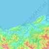
Asturias topographic map

Click on the map to display elevation.

About this map
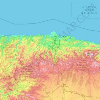
Name: Asturias topographic map, elevation, terrain.

Location: Asturias, Spain (42.88254 -7.18317 43.66653 -4.51059)

Average elevation: 565 m

Minimum elevation: -1 m

Maximum elevation: 2,528 m

Other topographic maps

Click on a map to view its topography, its elevation and its terrain.
Camino de Santiago

Spain > Castile and León > Zazuar

Average elevation: 848 m

Bizkaia

Spain > Pirinioak / Pirineo > Garde

Average elevation: 1,225 m

Ordesa

Spain > Aragon > Los Monegros > Almuniente

Average elevation: 341 m

Sorriba del Esla

Spain > Castile and León > Cistierna

Average elevation: 1,021 m

Maspalomas

Spain > Maspalomas

Average elevation: 53 m

Pechón

Spain > Cantabria > Val de San Vicente

Average elevation: 41 m

La Pared

Spain > Pájara

Average elevation: 71 m

Ayagaures

Spain > San Bartolomé de Tirajana

Average elevation: 535 m

Sahechores de Rueda

Spain > Castile and León

Average elevation: 885 m

Toroño

Spain > Castile and León > Porto

Average elevation: 1,495 m

Valsain

Spain > Aragon > Campo de Daroca > Villarroya del Campo

Average elevation: 962 m

Bescós de Garcipollera

Spain > Aragon > Jacetania > Jaca

Average elevation: 1,122 m

el Tor

Spain > Catalonia > Ripollès > Gombrèn

Average elevation: 1,152 m

Aspa

Spain > Catalonia > Aspa

Average elevation: 266 m

Río de la Mora

Spain > Castile and León > Navalacruz

Average elevation: 1,495 m

Cumbre Vieja

Spain > Santa Cruz de Tenerife > Villa de Mazo

Average elevation: 1,480 m

Las Navas

Spain > Andalusia > Priego de Córdoba

Average elevation: 926 m

Córdoba

Spain > Andalusia > Córdoba

Average elevation: 262 m

Las Catorce

Spain > Andalusia > Sierra de Cádiz > El Bosque

Average elevation: 364 m

Castroañe

Spain > Castile and León > Villaselán

Average elevation: 873 m

Guama

Spain > Santiago del Teide

Average elevation: 569 m

La Pimpana

Spain > Asturias > Quirós

Average elevation: 1,683 m

Murcia

Spain > Region of Murcia > Region of Murcia > Murcia

Murcia is located near the center of a low-lying fertile plain known as the huerta (orchard or vineyard) of Murcia. The Segura River and its right-hand tributary, the Guadalentín, run through the area. The city has an elevation of 43 metres (141 ft) above sea level and its municipality covers approximately…

Average elevation: 169 m
Calgar

Spain > Cantabria > Trasmiera

Average elevation: 150 m

Puente Nuevo

Spain > Andalusia > Alcaudete

Average elevation: 642 m

Castillo de Alba

Spain > Castile and León > Losacino

Average elevation: 745 m

Crispín

Spain > Andalusia > Aznalcóllar

Average elevation: 66 m

Gear up for your next adventure:

🥾Mountain Trail Shoes - High-traction shoes for mountain trails
🦟Insect Repellent - Keep mosquitoes and black flies away in wooded areas
🧴Outdoor Sunscreen - High SPF protection for high-altitude UV exposure
🔋Emergency Crank Radio - Weather alerts and power without needing batteries
👟Leg Gaiters - Keep debris, mud, and snow out of your boots

As an Amazon Associate, this site earns from qualifying purchases at no extra cost to you.