
Sainte-Anne topographic map
Click on the map to display elevation.
About this map
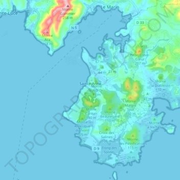
Name: Sainte-Anne topographic map, elevation, terrain.
Location: Sainte-Anne, Le Marin, Martinique, 97227, France (14.38867 -60.89345 14.47427 -60.80970)
Average elevation: 20 m
Minimum elevation: -1 m
Maximum elevation: 263 m
Other topographic maps
Click on a map to view its topography, its elevation and its terrain.
Fort-de-France
France > Martinique > Fort-de-France > Fort-de-France
La topographie est très variée. La commune de Fort-de-France s'étire des contreforts du massif volcanique des Pitons du Carbet (le point culminant de la commune atteint environ 1 100 mètres d'altitude, près du sommet du Piton Dumauzé) et du Morne Césaire (603 mètres) jusqu'à la mer des Caraïbes. Les…
Average elevation: 42 m