Geolocate

Constant topographic map

Click on the map to display elevation.

About this map

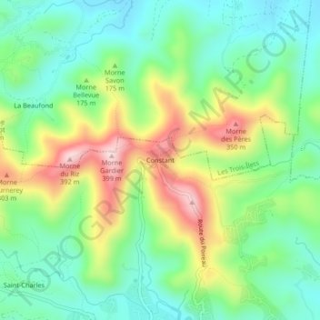
Name: Constant topographic map, elevation, terrain.

Location: Constant, Le Diamant, Le Marin, Martinique, 97223, France (14.48607 -61.04120 14.52607 -61.00120)

Average elevation: 136 m

Minimum elevation: 8 m

Maximum elevation: 369 m

Other topographic maps

Click on a map to view its topography, its elevation and its terrain.

Rocher du Diamant

France > Martinique > Le Diamant

Average elevation: 0 m

Plage d'Anse Cafard

France > Martinique > Le Diamant

Average elevation: 78 m

Gear up for your next adventure:

🧼Biodegradable Camp Soap - Environmentally friendly cleaning for gear and body
🧤Rechargeable Heated Gloves - Extreme warmth for Canadian winter expeditions
🧥Insulated Jacket - Keep warm in cold outdoor conditions
🧢Hiking Hat - Sun-protective and breathable hats for long treks
💡LED Camping Lantern - Illuminate your campsite with long-lasting lanterns

As an Amazon Associate, this site earns from qualifying purchases at no extra cost to you.