
Hamlet of Keephills topographic map
Interactive map
Click on the map to display elevation.
About this map
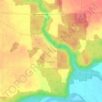
Name: Hamlet of Keephills topographic map, elevation, terrain.
Location: Hamlet of Keephills, Division No. 11, Alberta, Canada (53.43980 -114.35741 53.44876 -114.34585)
Average elevation: 712 m
Minimum elevation: 662 m
Maximum elevation: 747 m
Division No. 11 trails, hiking, mountain biking, running and outdoor activities
Other topographic maps
Click on a map to view its topography, its elevation and its terrain.
Louise McKinney Riverfront Park
Canada > Alberta > Division No. 11 > Edmonton
Average elevation: 647 m