Geolocate

Westerose topographic map

Click on the map to display elevation.

About this map

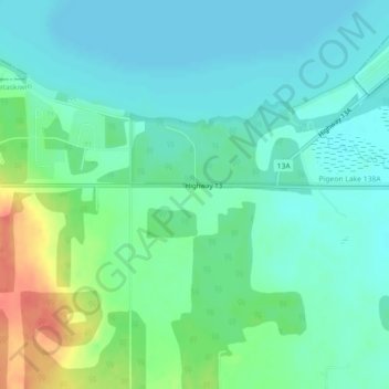
Name: Westerose topographic map, elevation, terrain.

Location: Westerose, Division No. 11, Alberta, T0C 2V0, Canada (52.94906 -114.00447 52.96906 -113.98447)

Average elevation: 860 m

Minimum elevation: 845 m

Maximum elevation: 898 m

Division No. 11 trails, hiking, mountain biking, running and outdoor activities

Other topographic maps

Click on a map to view its topography, its elevation and its terrain.

Saunders Lake

Canada > Alberta > Division No. 11

Average elevation: 721 m

Wolf Willow

Canada > Alberta > Division No. 11

Average elevation: 665 m

Big Lake

Canada > Alberta > Division No. 11 > St. Albert

Average elevation: 669 m

Thorncliff Park

Canada > Alberta > Division No. 11 > Edmonton

Average elevation: 677 m

Inglewood

Canada > Alberta > Division No. 11 > Edmonton

Average elevation: 671 m

Paul Kane Park

Canada > Alberta > Division No. 11 > Edmonton

Average elevation: 655 m

Half Moon Lake

Canada > Alberta > Division No. 11

Average elevation: 752 m

Ogilvie Ridge

Canada > Alberta > Division No. 11

Average elevation: 673 m

Wabamun Lake

Canada > Alberta > Division No. 11 > Seba Beach

Average elevation: 758 m

Casselman

Canada > Alberta > Division No. 11

Average elevation: 674 m

Avenue District

Canada > Alberta > Division No. 11 > Edmonton

Average elevation: 663 m

Gear up for your next adventure:

🛌Insulated Sleeping Pad - Critical thermal barrier between you and the cold ground
🎒Hiking Backpack - Lightweight and ergonomic backpacks for day hikes or multi-day treks
💡LED Camping Lantern - Illuminate your campsite with long-lasting lanterns
🧦Thermal Socks - Warm socks for winter hiking or camping
🩹Moleskin Blister Pads - Direct protection for painful foot pressure points

As an Amazon Associate, this site earns from qualifying purchases at no extra cost to you.