Geolocate

Big Lake topographic map

Click on the map to display elevation.

About this map

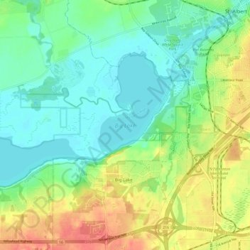
Name: Big Lake topographic map, elevation, terrain.

Location: Big Lake, St. Albert, Division No. 11, Alberta, Canada (53.58137 -113.77477 53.62221 -113.65876)

Average elevation: 669 m

Minimum elevation: 648 m

Maximum elevation: 704 m

Division No. 11 trails, hiking, mountain biking, running and outdoor activities

Gear up for your next adventure:

🥾Light Hiking Boots - Lightweight and comfortable boots for day hikes
🪜Heavy Duty Carabiners - Multi-use clips for securing gear to your backpack
💡Portable Camping Lamp - Rechargeable lamp for campsite lighting
🥾Trail Hiking Boots - Supportive boots for rough trails
🥾Mountain Hiking Boots - High-traction boots for rocky terrain

As an Amazon Associate, this site earns from qualifying purchases at no extra cost to you.