
Vojvodina topographic map
Interactive map
Click on the map to display elevation.
About this map
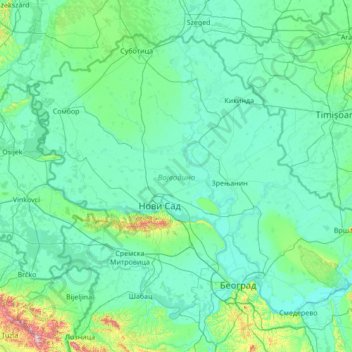
Name: Vojvodina topographic map, elevation, terrain.
Location: Vojvodina, Serbia (44.62973 18.81499 46.19028 21.56013)
Average elevation: 110 m
Minimum elevation: 66 m
Maximum elevation: 860 m
Today, the western part of Syrmia is in Croatia, the northern part of Bačka is in Hungary, the eastern part of Banat is in Romania (with a small piece in Hungary), while Baranja (which is between the Danube and the Drava) is in Hungary and Croatia. Vojvodina has a total surface area of 21,500 km2 (8,300 sq mi). Vojvodina is also part of the Danube-Kris-Mures-Tisa euroregion. The Gudurica peak (Gudurički vrh) on the Vršac Mountains, is the highest peak in Vojvodina, at an altitude of 641 m above sea level.
Other topographic maps
Click on a map to view its topography, its elevation and its terrain.
Niš
Serbia > Central Serbia > Nisava Administrative District
Niš, City of Niš, Nisava Administrative District, Central Serbia, 18101, Serbia
Average elevation: 365 m
Jakovo
Serbia > Central Serbia > City of Belgrade > Surcin Urban Municipality
Jakovo, Surcin Urban Municipality, City of Belgrade, Central Serbia, 11276, Serbia
Average elevation: 75 m
Pruzatovac
Serbia > Central Serbia > City of Belgrade > Mladenovac Urban Municipality
Pruzatovac, Mladenovac Urban Municipality, City of Belgrade, Central Serbia, Serbia
Average elevation: 179 m
Brezovac
Serbia > Central Serbia > Sumadija Administrative District > Arandjelovac Municipality
Brezovac, Arandjelovac Municipality, Sumadija Administrative District, Central Serbia, Serbia
Average elevation: 380 m
Stojnik
Serbia > Central Serbia > City of Belgrade > Sopot Urban Municipality
Stojnik, Sopot Urban Municipality, City of Belgrade, Central Serbia, Serbia
Average elevation: 230 m
Kalanjevci
Serbia > Central Serbia > Kolubara Administrative District > Ljig Municipality
Kalanjevci, Ljig Municipality, Kolubara Administrative District, Central Serbia, Serbia
Average elevation: 279 m
Rogaca
Serbia > Central Serbia > City of Belgrade > Sopot Urban Municipality
Rogaca, Sopot Urban Municipality, City of Belgrade, Central Serbia, Serbia
Average elevation: 241 m
Gornja Tresnjevica
Serbia > Central Serbia > Sumadija Administrative District > Arandjelovac Municipality
Gornja Tresnjevica, Arandjelovac Municipality, Sumadija Administrative District, Central Serbia, Serbia
Average elevation: 385 m
Sovljak
Serbia > Central Serbia > Kolubara Administrative District > Ub Municipality
Sovljak, Ub Municipality, Kolubara Administrative District, Central Serbia, Serbia
Average elevation: 107 m
Siljakovac
Serbia > Central Serbia > City of Belgrade > Barajevo Urban Municipality
Siljakovac, Barajevo Urban Municipality, City of Belgrade, Central Serbia, 11462, Serbia
Average elevation: 164 m
Vukosavci
Serbia > Central Serbia > Sumadija Administrative District > Arandjelovac Municipality
Vukosavci, Arandjelovac Municipality, Sumadija Administrative District, Central Serbia, Serbia
Average elevation: 388 m
Jermenovci
Serbia > Vojvodina > South Banat Administrative District > Plandiste Municipality
Jermenovci, Plandiste Municipality, South Banat Administrative District, Vojvodina, 26363, Serbia
Average elevation: 77 m
Jagnjilo
Serbia > Central Serbia > City of Belgrade > Mladenovac Urban Municipality
Jagnjilo, Mladenovac Urban Municipality, City of Belgrade, Central Serbia, Serbia
Average elevation: 155 m
Meljak
Serbia > Central Serbia > City of Belgrade > Barajevo Urban Municipality
Meljak, Barajevo Urban Municipality, City of Belgrade, Central Serbia, Serbia
Average elevation: 199 m
Gruza
Serbia > Central Serbia > Sumadija Administrative District > Knic Municipality
Gruza, Knic Municipality, Sumadija Administrative District, Central Serbia, 34230, Serbia
Average elevation: 258 m
Ravna Gora
Serbia > Central Serbia > Jablanica Administrative District > Vlasotince Municipality
Ravna Gora, Vlasotince Municipality, Jablanica Administrative District, Central Serbia, Serbia
Average elevation: 877 m
Vrbica
Serbia > Central Serbia > Sumadija Administrative District > Arandjelovac Municipality
Vrbica, Arandjelovac Municipality, Sumadija Administrative District, Central Serbia, Serbia
Average elevation: 373 m
Cacak
Serbia > Central Serbia > Moravica Administrative District > Čačak
Cacak, Čačak, City of Čačak, Moravica Administrative District, Central Serbia, 32000, Serbia
Average elevation: 274 m
Arandjelovac
Serbia > Central Serbia > Sumadija Administrative District > Arandjelovac Municipality
Arandjelovac, Arandjelovac Municipality, Sumadija Administrative District, Central Serbia, 34300, Serbia
Average elevation: 326 m
Lisovic
Serbia > Central Serbia > City of Belgrade > Barajevo Urban Municipality
Lisovic, Barajevo Urban Municipality, City of Belgrade, Central Serbia, 11460, Serbia
Average elevation: 206 m
Manic
Serbia > Central Serbia > City of Belgrade > Barajevo Urban Municipality
Manic, Barajevo Urban Municipality, City of Belgrade, Central Serbia, Serbia
Average elevation: 177 m
Sovljak
Serbia > Central Serbia > Macva Administrative District > Bogatic Municipality
Sovljak, Bogatic Municipality, Macva Administrative District, Central Serbia, 15362, Serbia
Average elevation: 83 m
Rusanj
Serbia > Central Serbia > City of Belgrade > Cukarica Urban Municipality
Rusanj, Cukarica Urban Municipality, City of Belgrade, Central Serbia, 11194, Serbia
Average elevation: 207 m
Guncati
Serbia > Central Serbia > City of Belgrade > Barajevo Urban Municipality
Guncati, Barajevo Urban Municipality, City of Belgrade, Central Serbia, 11460, Serbia
Average elevation: 189 m
Progoreoci
Serbia > Central Serbia > Sumadija Administrative District > Arandjelovac Municipality
Progoreoci, Arandjelovac Municipality, Sumadija Administrative District, Central Serbia, Serbia
Average elevation: 262 m
Nemenikuce
Serbia > Central Serbia > City of Belgrade > Sopot Urban Municipality
Nemenikuce, Sopot Urban Municipality, City of Belgrade, Central Serbia, 11450, Serbia
Average elevation: 249 m
Vrhovine
Serbia > Central Serbia > Kolubara Administrative District > Ub Municipality
Vrhovine, Ub Municipality, Kolubara Administrative District, Central Serbia, Serbia
Average elevation: 198 m
Rakari
Serbia > Central Serbia > Kolubara Administrative District > Mionica Municipality
Rakari, Mionica Municipality, Kolubara Administrative District, Central Serbia, Serbia
Average elevation: 209 m
Poljanice
Serbia > Central Serbia > Kolubara Administrative District > Ljig Municipality
Poljanice, Ljig Municipality, Kolubara Administrative District, Central Serbia, Serbia
Average elevation: 223 m
Dici
Serbia > Central Serbia > Kolubara Administrative District > Ljig Municipality
Dici, Ljig Municipality, Kolubara Administrative District, Central Serbia, Serbia
Average elevation: 273 m
Trlic
Serbia > Central Serbia > Kolubara Administrative District > Ub Municipality
Trlic, Ub Municipality, Kolubara Administrative District, Central Serbia, Serbia
Average elevation: 127 m
Koracica
Serbia > Central Serbia > City of Belgrade > Mladenovac Urban Municipality
Koracica, Mladenovac Urban Municipality, City of Belgrade, Central Serbia, Serbia
Average elevation: 251 m
Paljuvi
Serbia > Central Serbia > Kolubara Administrative District > Ub Municipality
Paljuvi, Ub Municipality, Kolubara Administrative District, Central Serbia, Serbia
Average elevation: 129 m
Gornjane
Serbia > Central Serbia > Bor Administrative District
Gornjane, City of Bor, Bor Administrative District, Central Serbia, Serbia
Average elevation: 457 m
Mali Mirasevac
Serbia > Central Serbia > Sumadija Administrative District > Raca Municipality
Mali Mirasevac, Raca Municipality, Sumadija Administrative District, Central Serbia, Serbia
Average elevation: 148 m
Bozdarevac
Serbia > Central Serbia > City of Belgrade > Barajevo Urban Municipality
Bozdarevac, Barajevo Urban Municipality, City of Belgrade, Central Serbia, 11460, Serbia
Average elevation: 160 m
Ranilovic
Serbia > Central Serbia > Sumadija Administrative District > Arandjelovac Municipality
Ranilovic, Arandjelovac Municipality, Sumadija Administrative District, Central Serbia, Serbia
Average elevation: 198 m
Dragolj
Serbia > Central Serbia > Moravica Administrative District > Gornji Milanovac Municipality
Dragolj, Gornji Milanovac Municipality, Moravica Administrative District, Central Serbia, Serbia
Average elevation: 292 m
Kamenica
Serbia > Central Serbia > Sumadija Administrative District
Kamenica, City of Kragujevac, Sumadija Administrative District, Central Serbia, Serbia
Average elevation: 522 m
Kopljare
Serbia > Central Serbia > Sumadija Administrative District > Arandjelovac Municipality
Kopljare, Arandjelovac Municipality, Sumadija Administrative District, Central Serbia, 34312, Serbia
Average elevation: 213 m
Tulez
Serbia > Central Serbia > Sumadija Administrative District > Arandjelovac Municipality
Tulez, Arandjelovac Municipality, Sumadija Administrative District, Central Serbia, Serbia
Average elevation: 168 m
Ropocevo
Serbia > Central Serbia > City of Belgrade > Sopot Urban Municipality
Ropocevo, Sopot Urban Municipality, City of Belgrade, Central Serbia, Serbia
Average elevation: 238 m
Poskurice
Serbia > Central Serbia > Sumadija Administrative District
Poskurice, City of Kragujevac, Sumadija Administrative District, Central Serbia, Serbia
Average elevation: 260 m
Jovanovac (Merošina)
Serbia > Central Serbia > Nisava Administrative District > Merosina Municipality
Jovanovac (Merošina), Merosina Municipality, Nisava Administrative District, Central Serbia, Serbia
Average elevation: 385 m
Dragobraca
Serbia > Central Serbia > Sumadija Administrative District
Dragobraca, City of Kragujevac, Sumadija Administrative District, Central Serbia, 34231, Serbia
Average elevation: 276 m
Veliki Senj
Serbia > Central Serbia > Sumadija Administrative District
Veliki Senj, City of Kragujevac, Sumadija Administrative District, Central Serbia, Serbia
Average elevation: 464 m
Ozrem
Serbia > Central Serbia > Moravica Administrative District > Gornji Milanovac Municipality
Ozrem, Gornji Milanovac Municipality, Moravica Administrative District, Central Serbia, Serbia
Average elevation: 459 m
Trudelj
Serbia > Central Serbia > Moravica Administrative District > Gornji Milanovac Municipality
Trudelj, Gornji Milanovac Municipality, Moravica Administrative District, Central Serbia, Serbia
Average elevation: 394 m
Djuriselo
Serbia > Central Serbia > Sumadija Administrative District
Djuriselo, City of Kragujevac, Sumadija Administrative District, Central Serbia, 34231, Serbia
Average elevation: 322 m
Brzan
Serbia > Central Serbia > Sumadija Administrative District > Batocina Municipality
Brzan, Batocina Municipality, Sumadija Administrative District, Central Serbia, Serbia
Average elevation: 142 m