
Thank you for supporting this site ❤️
Make a donation
Make a donation
Gear up for your next adventure:
As an Amazon Associate, this site earns from qualifying purchases at no extra cost to you.
Ropocevo topographic map
Click on the map to display elevation.
Thank you for supporting this site ❤️
Make a donation
Make a donation
Gear up for your next adventure:
As an Amazon Associate, this site earns from qualifying purchases at no extra cost to you.
About this map
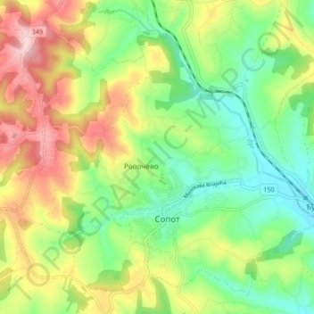
Name: Ropocevo topographic map, elevation, terrain.
Average elevation: 238 m
Minimum elevation: 152 m
Maximum elevation: 362 m
Thank you for supporting this site ❤️
Make a donation
Make a donation
Gear up for your next adventure:
As an Amazon Associate, this site earns from qualifying purchases at no extra cost to you.
Other topographic maps
Click on a map to view its topography, its elevation and its terrain.
Nemenikuce
Serbia > Central Serbia > City of Belgrade > Sopot Urban Municipality
Average elevation: 249 m
Stojnik
Serbia > Central Serbia > City of Belgrade > Sopot Urban Municipality
Average elevation: 230 m