Geolocate

Sunrise topographic map

Click on the map to display elevation.

About this map

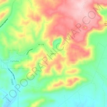
Name: Sunrise topographic map, elevation, terrain.

Location: Sunrise, Platte County, Wyoming, 82215, United States (42.31025 -104.72552 42.35025 -104.68552)

Average elevation: 1,502 m

Minimum elevation: 1,384 m

Maximum elevation: 1,640 m

Other topographic maps

Click on a map to view its topography, its elevation and its terrain.

Wheatland

United States > Wyoming > Platte County

Average elevation: 1,454 m

Guernsey

United States > Wyoming > Platte County

Average elevation: 1,332 m

Slater

United States > Wyoming > Platte County

Average elevation: 1,579 m

Guernsey

United States > Wyoming > Platte County

Average elevation: 1,332 m

Gear up for your next adventure:

🥾Lightweight Hiking Boots - Boots for comfort and mobility on long hikes
🧦Hiking Liner Socks - Thin base layer to prevent friction and blisters
🧦Merino Wool Socks - Moisture-wicking comfort for long-distance hiking
💡Portable Camping Lamp - Rechargeable lamp for campsite lighting
🪑Ultralight Camping Stool - Compact seating for rest stops during long hikes

As an Amazon Associate, this site earns from qualifying purchases at no extra cost to you.