
Make a donation
Gear up for your next adventure:
As an Amazon Associate, this site earns from qualifying purchases at no extra cost to you.
Busia topographic map
Click on the map to display elevation.
Make a donation
Gear up for your next adventure:
As an Amazon Associate, this site earns from qualifying purchases at no extra cost to you.
About this map
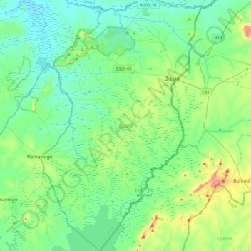
Name: Busia topographic map, elevation, terrain.
Location: Busia, Eastern Region, Uganda (0.19040 33.87902 0.59315 34.13823)
Average elevation: 1,168 m
Minimum elevation: 1,066 m
Maximum elevation: 1,564 m
Make a donation
Gear up for your next adventure:
As an Amazon Associate, this site earns from qualifying purchases at no extra cost to you.
Other topographic maps
Click on a map to view its topography, its elevation and its terrain.
Make a donation
Gear up for your next adventure:
As an Amazon Associate, this site earns from qualifying purchases at no extra cost to you.
Make a donation
Gear up for your next adventure:
As an Amazon Associate, this site earns from qualifying purchases at no extra cost to you.
Make a donation
Gear up for your next adventure:
As an Amazon Associate, this site earns from qualifying purchases at no extra cost to you.
Kisoro
Kisoro is approximately 76 kilometres (47 mi), by road, west of Kabale, the largest city in the Kigezi sub-region.[2] This is approximately 484 kilometres (301 mi), by road, southwest of Kampala, the capital of Uganda and the country's largest city.[3] Kisoro is east of Rumangabo and the Virunga Mountains in…
Average elevation: 1,911 m
Bundibugyo
The geographical coordinates of Bundibugyo town are:0°42'45.0"N 30°03'36.0"E (Latitude:0.712500; Longitude: 30.059999). Bundibugyo Town Council sits at an average elevation of 3,461 feet (1,055 m) above mean sea level, lying between 2,477 feet (755 m) and 7,733 feet (2,357 m) above sea level.
Average elevation: 994 m
Make a donation
Gear up for your next adventure:
As an Amazon Associate, this site earns from qualifying purchases at no extra cost to you.