
Make a donation
Gear up for your next adventure:
As an Amazon Associate, this site earns from qualifying purchases at no extra cost to you.
Kisoro topographic map
Click on the map to display elevation.
Make a donation
Gear up for your next adventure:
As an Amazon Associate, this site earns from qualifying purchases at no extra cost to you.
Kisoro
Kisoro is approximately 76 kilometres (47 mi), by road, west of Kabale, the largest city in the Kigezi sub-region.[2] This is approximately 484 kilometres (301 mi), by road, southwest of Kampala, the capital of Uganda and the country's largest city.[3] Kisoro is east of Rumangabo and the Virunga Mountains in the Democratic Republic of the Congo (DRC). The geographical coordinates of Kisoro are 1°17'06.0"S, 29°41'06.0"E (Latitude:-1.2850; Longitude:29.6850).[4] Kisoro Town Council sits at an average elevation of 1,929 metres (6,329 ft), above mean sea level.[5]
Make a donation
Gear up for your next adventure:
As an Amazon Associate, this site earns from qualifying purchases at no extra cost to you.
About this map
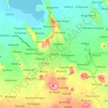
Name: Kisoro topographic map, elevation, terrain.
Location: Kisoro, Cyanika, Kisoro, Western Region, Uganda (-1.32221 29.65267 -1.24221 29.73267)
Average elevation: 1,911 m
Minimum elevation: 1,781 m
Maximum elevation: 2,170 m
Make a donation
Gear up for your next adventure:
As an Amazon Associate, this site earns from qualifying purchases at no extra cost to you.