
Thank you for supporting this site ❤️
Make a donation
Make a donation
Gear up for your next adventure:
As an Amazon Associate, this site earns from qualifying purchases at no extra cost to you.
Kamukuzi topographic map
Click on the map to display elevation.
Thank you for supporting this site ❤️
Make a donation
Make a donation
Gear up for your next adventure:
As an Amazon Associate, this site earns from qualifying purchases at no extra cost to you.
About this map
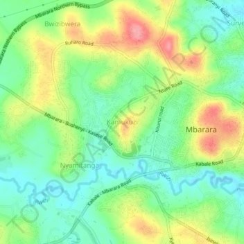
Name: Kamukuzi topographic map, elevation, terrain.
Location: Kamukuzi, Mbarara City, Western Region, Uganda (-0.62958 30.62034 -0.58958 30.66034)
Average elevation: 1,419 m
Minimum elevation: 1,381 m
Maximum elevation: 1,476 m
Thank you for supporting this site ❤️
Make a donation
Make a donation
Gear up for your next adventure:
As an Amazon Associate, this site earns from qualifying purchases at no extra cost to you.