
Thank you for supporting this site ❤️
Make a donation
Make a donation
Gear up for your next adventure:
As an Amazon Associate, this site earns from qualifying purchases at no extra cost to you.
Kireku-bugolo topographic map
Click on the map to display elevation.
Thank you for supporting this site ❤️
Make a donation
Make a donation
Gear up for your next adventure:
As an Amazon Associate, this site earns from qualifying purchases at no extra cost to you.
About this map
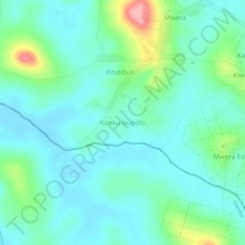
Name: Kireku-bugolo topographic map, elevation, terrain.
Location: Kireku-bugolo, Mityana, Central Region, Uganda (0.27703 32.08938 0.31703 32.12938)
Average elevation: 1,208 m
Minimum elevation: 1,177 m
Maximum elevation: 1,318 m
Thank you for supporting this site ❤️
Make a donation
Make a donation
Gear up for your next adventure:
As an Amazon Associate, this site earns from qualifying purchases at no extra cost to you.