Geolocate

Cedral topographic map

Click on the map to display elevation.

About this map

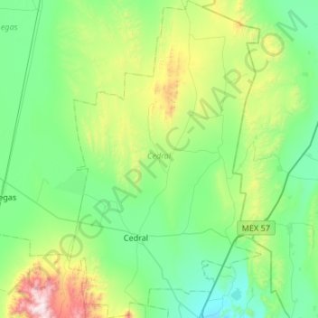
Name: Cedral topographic map, elevation, terrain.

Location: Cedral, San Luis Potosi, Mexico (23.69726 -100.83727 24.18316 -100.51313)

Average elevation: 1,853 m

Minimum elevation: 1,542 m

Maximum elevation: 3,027 m

Other topographic maps

Click on a map to view its topography, its elevation and its terrain.

Real de Catorce

Mexico > San Luis Potosi > Catorce

Although in the southern range of the Chihuahuan desert, due to its elevation, Real can be very cool at night. Although days, particularly in summer, can be very hot, it is advised to always bring a jacket, even in summer.

Average elevation: 2,671 m

Salinas de Hidalgo

Mexico > San Luis Potosi > Salinas

Average elevation: 2,096 m

Jalpilla

Mexico > San Luis Potosi > Axtla de Terrazas

Average elevation: 127 m

Guerrero

Mexico > San Luis Potosi > San Ciro de Acosta

Average elevation: 1,140 m

La Silleta

Mexico > San Luis Potosi > Xilitla

Average elevation: 1,353 m

Río Verde

Mexico > San Luis Potosi > Ciudad Fernández

Average elevation: 1,007 m

Tamuín

Mexico > San Luis Potosi > Tamuín

Average elevation: 25 m

Ahuacatlán

Mexico > San Luis Potosi > Xilitla

Average elevation: 1,321 m

La Lima

Mexico > San Luis Potosi > Ciudad Valles > Ciudad Valles

Average elevation: 198 m

Ciudad Valles

Mexico > San Luis Potosi > Ciudad Valles

Average elevation: 181 m

Tamul Waterfall

Mexico > San Luis Potosi > Aquismón

Average elevation: 236 m

Gear up for your next adventure:

💧Hydration Bladder - Hands-free hydration solution for long treks
🌡️Emergency Mylar Blankets - Compact thermal protection for unexpected nights outdoors
🥾Approach Boots - Comfortable boots for hiking and climbing approaches
🥾Waterproof Hiking Boots - Essential footwear for rugged terrain and wet Canadian trails
💡LED Headlamp - Hands-free illumination for night hiking and camping

As an Amazon Associate, this site earns from qualifying purchases at no extra cost to you.