
Cold Creek topographic map
Click on the map to display elevation.
About this map
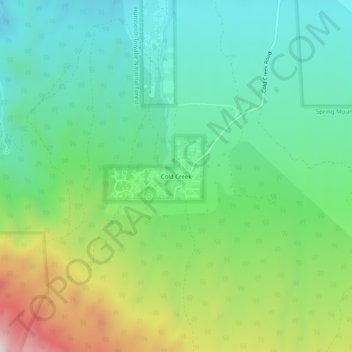
Name: Cold Creek topographic map, elevation, terrain.
Location: Cold Creek, Clark County, Nevada, United States (36.39407 -115.76028 36.43407 -115.72028)
Average elevation: 1,936 m
Minimum elevation: 1,706 m
Maximum elevation: 2,444 m
Other topographic maps
Click on a map to view its topography, its elevation and its terrain.
Las Vegas
United States > Nevada > Clark County
The peaks surrounding Las Vegas reach elevations of over 10,000 feet (3,000 m), and act as barriers to the strong flow of moisture from the surrounding area. The elevation is approximately 2,030 ft (620 m) above sea level. According to the United States Census Bureau, the city has a total area of 135.86 sq mi…
Average elevation: 767 m
Las Vegas
United States > Nevada > Clark County
Las Vegas is characterized by its distinctive topography, which features a mix of arid desert landscapes and mountainous terrain. The city itself sits at an elevation of approximately 2,030 feet (620 meters) above sea level, while the surrounding peaks reach heights exceeding 10,000 feet (3,000 meters),…
Average elevation: 767 m
Mount Charleston
United States > Nevada > Clark County > Mount Charleston
The town of Mount Charleston is named for nearby Mount Charleston whose Charleston Peak at 11,916 feet (3,632 m) is the highest point in Clark County. The town of Mount Charleston is in a valley of the Spring Mountains to the northwest of Las Vegas, noted for its hiking trails. It is also known for its Retreat…
Average elevation: 2,560 m
Henderson
United States > Nevada > Clark County
Henderson is a city in Clark County, Nevada, United States, about 16 miles (26 km) southeast of downtown Las Vegas. It is the second largest city in Nevada, after Las Vegas, with an estimated population of 320,189 in 2019. The city is part of the Las Vegas Valley. Henderson occupies the southeastern end of the…
Average elevation: 688 m
Las Vegas Valley
United States > Nevada > Clark County
The Las Vegas Valley lies in a relatively high-altitude portion of the Mojave Desert, with a subtropical hot-desert climate. The Valley generally averages less than 5 in (130 mm) of rain annually. Daily daytime summer temperatures in July and August typically range from 100 °F (38 °C) to 110 °F (43 °C),…
Average elevation: 892 m
North Las Vegas
United States > Nevada > Clark County
On May 13, 1964, First Lieutenant Raynor Lee Hebert, a student pilot from Port Arthur, Texas, took off from Nellis Air Force Base at approximately 2:00 PM on an F-105 fighter jet. He radioed his flight leader saying that he could not retract his nose gear, and thus couldn't gain altitude. He was at an height…
Average elevation: 858 m
Searchlight
United States > Nevada > Clark County > Searchlight
Searchlight is an unincorporated town and census-designated place (CDP) in Clark County, Nevada, United States, at the topographic saddle between two mountain ranges. At the 2020 census it had a population of 445.
Average elevation: 1,087 m
Blue Diamond
United States > Nevada > Clark County > Blue Diamond
Blue Diamond is the site of Cottonwood Spring (formerly known as Ojo de Cayetana, or Pearl Spring), a watering place and camp site on the Old Spanish Trail and the later Mormon Road between Mountain Springs and Las Vegas Springs. The springs are located on a mountainside south of the town at 36°02′44″N…
Average elevation: 1,102 m
Craig Ranch Regional Park
United States > Nevada > Clark County > North Las Vegas
Average elevation: 626 m
Spring Mountain Ranch State Park
United States > Nevada > Clark County
"Because of the higher elevation, the ranch offers a diverse opportunity for plant study. Four plant communities are represented: Desert Scrub, Black brush, Pinon-Juniper, and Riparian. Plants typical of the desert as well as woodland can be seen, and with adequate rainfall the spring brings a burst of…
Average elevation: 1,188 m
Indian Springs
United States > Nevada > Clark County > Indian Springs
One year later, Indian Springs was reactivated as Indian Springs Air Force Base by the new United States Air Force, with a new role as a new weapons systems and aircraft research and testing. Among these missions were support for nuclear arms testing at the Nevada Proving Grounds, high-altitude balloon search…
Average elevation: 1,078 m
Summerlin South
United States > Nevada > Clark County > Las Vegas > Summerlin South
Average elevation: 917 m
Las Vegas Valley
United States > Nevada > Clark County
The Las Vegas Valley lies in a relatively high-altitude portion of the Mojave Desert, with a subtropical hot-desert climate. The Valley generally averages less than 5 in (130 mm) of rain annually. Daily daytime summer temperatures in July and August typically range from 100 °F (38 °C) to 110 °F (43 °C),…
Average elevation: 840 m
North Las Vegas
United States > Nevada > Clark County
On May 13, 1964, First Lieutenant Raynor Lee Hebert, a student pilot from Port Arthur, Texas, took off from Nellis Air Force Base at approximately 2:00 PM on an F-105 fighter jet. He radioed his flight leader saying that he could not retract his nose gear, and thus could not gain altitude. He was at a height…
Average elevation: 858 m
Henderson
United States > Nevada > Clark County
Henderson is a city in Clark County, Nevada, United States, about 16 miles (26 km) southeast of downtown Las Vegas. It is the second largest city in Nevada, after Las Vegas, with an estimated population of 320,189 in 2019. The city is part of the Las Vegas Valley. Henderson occupies the southeastern end of the…
Average elevation: 688 m
Henderson
United States > Nevada > Clark County
Henderson is a city in Clark County, Nevada, United States, about 16 miles (26 km) southeast of downtown Las Vegas. It is the second largest city in Nevada, after Las Vegas, with an estimated population of 320,189 in 2019. The city is part of the Las Vegas Valley. Henderson occupies the southeastern end of the…
Average elevation: 691 m
Las Vegas
United States > Nevada > Clark County
In 1829, Mexican trader and explorer Antonio Armijo led a group consisting of 60 men and 100 mules along the Old Spanish Trail from modern day New Mexico to California. Along the way, the group stopped in what would become Las Vegas and noted its natural water sources, now referred to as the Las Vegas Springs,…
Average elevation: 767 m
Las Vegas Valley
United States > Nevada > Clark County
The Las Vegas Valley lies in a relatively high-altitude portion of the Mojave Desert, with a subtropical hot-desert climate. The Valley generally averages less than 5 in (130 mm) of rain annually. Daily daytime summer temperatures in July and August typically range from 100 °F (38 °C) to 110 °F (43 °C),…
Average elevation: 892 m
Summerlin Centre Community Park
United States > Nevada > Clark County > Summerlin South > Summerlin Centre
Average elevation: 902 m
Indian Springs
United States > Nevada > Clark County > Indian Springs
One year later, Indian Springs was reactivated as Indian Springs Air Force Base by the new United States Air Force, with a new role as a new weapons systems and aircraft research and testing. Among these missions were support for nuclear arms testing at the Nevada Proving Grounds, high-altitude balloon search…
Average elevation: 1,078 m
Moapa Valley
United States > Nevada > Clark County
Moapa Valley is at an elevation of 1,265 ft (386 m) above sea level. The United States Census Bureau gives the census-designated place (CDP) of Moapa Valley (which may not coincide exactly with the town boundaries) a total area of 43.7 square miles (113.2 km2), of which 43.7 square miles (113.1 km2) is land…
Average elevation: 520 m
Las Vegas
United States > Nevada > Clark County
The peaks surrounding Las Vegas reach elevations of over 10,000 feet (3,000 m), and act as barriers to the strong flow of moisture from the surrounding area. The elevation is approximately 2,030 ft (620 m) above sea level. According to the United States Census Bureau, the city has a total area of 135.86 sq mi…
Average elevation: 767 m
Las Vegas Valley
United States > Nevada > Clark County
The Las Vegas Valley lies in a relatively high-altitude portion of the Mojave Desert, with a subtropical hot-desert climate. The Valley generally averages less than 5 in (130 mm) of rain annually. Daily daytime summer temperatures in July and August typically range from 100 °F (38 °C) to 110 °F (43 °C),…
Average elevation: 923 m
Henderson
United States > Nevada > Clark County
The War Department identified the area as being ideal for military industrial manufacturing. The area was at least 250 miles from the coast in between the McCullough Hills and River Mountains, protecting the area from low-altitude aircraft attacks. The area is also roughly halfway between the railroad line…
Average elevation: 688 m
Las Vegas
United States > Nevada > Clark County
The peaks surrounding Las Vegas reach elevations of over 10,000 feet (3,000 m) and act as barriers to the strong flow of moisture from the surrounding area. The elevation is approximately 2,030 ft (620 m) above sea level. According to the United States Census Bureau, the city has an area of 135.86 sq mi (351.9…
Average elevation: 767 m
Las Vegas
United States > Nevada > Clark County
The peaks surrounding Las Vegas reach elevations of over 10,000 feet (3,000 m), and act as barriers to the strong flow of moisture from the surrounding area. The elevation is approximately 2,030 ft (620 m) above sea level. According to the United States Census Bureau, the city has a total area of 135.86 sq mi…
Average elevation: 767 m
Las Vegas
United States > Nevada > Clark County
The city's elevation is approximately 2,030 ft (620 m) above sea level, though the surrounding peaks reach elevations of over 10,000 feet (3,000 m) and act as barriers to the strong flow of moisture from the surrounding area. According to the United States Census Bureau, the city has an area of 135.86 sq mi…
Average elevation: 767 m
Indian Springs
United States > Nevada > Clark County > Indian Springs
One year later, Indian Springs was reactivated as Indian Springs Air Force Base by the new United States Air Force, with a new role as a new weapons systems and aircraft research and testing. Among these missions were support for nuclear arms testing at the Nevada Proving Grounds, high-altitude balloon search…
Average elevation: 1,078 m
North Las Vegas
United States > Nevada > Clark County
On May 13, 1964, First Lieutenant Raynor Lee Hebert, a student pilot from Port Arthur, Texas, took off from Nellis Air Force Base at approximately 2:00 PM on an F-105 fighter jet. He radioed his flight leader saying that he could not retract his nose gear, and thus could not gain altitude. He was at a height…
Average elevation: 858 m
Las Vegas
United States > Nevada > Clark County
In 1829, Mexican trader and explorer Antonio Armijo led a group consisting of 60 men and 100 mules along the Old Spanish Trail from modern day New Mexico to California. Along the way, the group stopped in what would become Las Vegas and noted its natural water sources, now referred to as the Las Vegas Springs,…
Average elevation: 767 m
Searchlight
United States > Nevada > Clark County > Searchlight
Searchlight is an unincorporated town and census-designated place (CDP) in Clark County, Nevada, United States, at the topographic saddle between two mountain ranges. At the 2020 census it had a population of 445.
Average elevation: 1,088 m
Las Vegas
United States > Nevada > Clark County
The peaks surrounding Las Vegas reach elevations of over 10,000 feet (3,000 m), and act as barriers to the strong flow of moisture from the surrounding area. The elevation is approximately 2,030 ft (620 m) above sea level. According to the United States Census Bureau, the city has a total area of 135.86 sq mi…
Average elevation: 767 m
Valley of Fire State Park
United States > Nevada > Clark County
Valley of Fire is located in the Mojave Desert 50 miles (80 km) northeast of Las Vegas, at an elevation between 1,320–3,009 feet (402–917 m). It abuts the Lake Mead National Recreation Area on the east at the Virgin River confluence. It lies in a 4 by 6 mi (6.4 by 9.7 km) basin.
Average elevation: 626 m
Las Vegas Valley
United States > Nevada > Clark County
The Las Vegas Valley lies in a relatively high-altitude portion of the Mojave Desert, with a subtropical hot-desert climate. The Valley generally averages less than 5 in (130 mm) of rain annually. Daily daytime summer temperatures in July and August typically range from 100 °F (38 °C) to 110 °F (43 °C),…
Average elevation: 892 m
Moapa Valley
United States > Nevada > Clark County
Moapa Valley is at an elevation of 1,265 ft (386 m) above sea level. The United States Census Bureau gives the census-designated place (CDP) of Moapa Valley (which may not coincide exactly with the town boundaries) a total area of 43.7 square miles (113.2 km2), of which 43.7 square miles (113.1 km2) is land…
Average elevation: 525 m
Las Vegas Valley
United States > Nevada > Clark County
The Las Vegas Valley lies in a relatively high-altitude portion of the Mojave Desert, with a subtropical hot-desert climate. The Valley generally averages less than 5 in (130 mm) of rain annually. Daily daytime summer temperatures in July and August typically range from 100 °F (38 °C) to 110 °F (43 °C),…
Average elevation: 892 m
Mount Charleston
United States > Nevada > Clark County > Mount Charleston
The town of Mount Charleston is named for nearby Mount Charleston whose Charleston Peak at 11,916 feet (3,632 m) is the highest point in Clark County. The town of Mount Charleston is in a valley of the Spring Mountains to the northwest of Las Vegas, noted for its hiking trails. It is also known for its Retreat…
Average elevation: 2,560 m
Moapa Valley
United States > Nevada > Clark County
Moapa Valley is at an elevation of 1,265 ft (386 m) above sea level. The United States Census Bureau gives the census-designated place (CDP) of Moapa Valley (which may not coincide exactly with the town boundaries) a total area of 43.7 square miles (113.2 km2), of which 43.7 square miles (113.1 km2) is land…
Average elevation: 520 m
Henderson
United States > Nevada > Clark County
Henderson is a city in Clark County, Nevada, United States, about 16 miles (26 km) southeast of downtown Las Vegas. It is the second largest city in Nevada, after Las Vegas, with an estimated population of 320,189 in 2019. The city is part of the Las Vegas Valley. Henderson occupies the southeastern end of the…
Average elevation: 691 m