Geolocate

Paradise topographic map

Click on the map to display elevation.

About this map

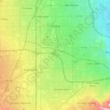
Name: Paradise topographic map, elevation, terrain.

Location: Paradise, Henderson, Clark County, Nevada, United States (35.98459 -115.20816 36.13713 -115.05933)

Average elevation: 645 m

Minimum elevation: 497 m

Maximum elevation: 1,071 m

Other topographic maps

Click on a map to view its topography, its elevation and its terrain.

Henderson

United States > Nevada > Clark County > Henderson

Average elevation: 662 m

Gear up for your next adventure:

🛶Waterproof Dry Bags - Keep electronics and clothes dry during river crossings
Bushcraft Tarp - Versatile emergency shelter or gear protection
❄️Traction Ice Cleats - Slip-on spikes for icy trails and winter hiking
🛁Quick-Dry Microfiber Towel - Space-saving towel that dries rapidly on the move
🥾Hiking Leggings - Comfortable leggings for outdoor activities

As an Amazon Associate, this site earns from qualifying purchases at no extra cost to you.