Douglas County topographic map
Interactive map
Click on the map to display elevation.
About this map
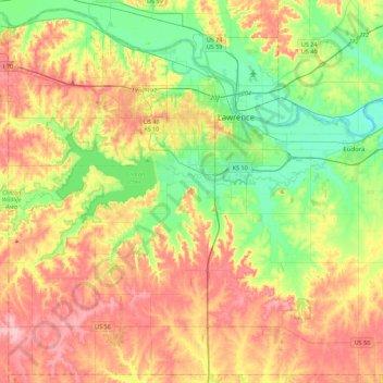
Name: Douglas County topographic map, elevation, terrain.
Location: Douglas County, Kansas, United States (38.73848 -95.50150 39.06978 -95.05589)
Average elevation: 294 m
Minimum elevation: 237 m
Maximum elevation: 365 m
Other topographic maps
Click on a map to view its topography, its elevation and its terrain.
Johnson County
The natural topography of the county consists of gently rolling terrain. The Kansas River forms a portion of the northwest boundary of the county. The elevation generally increases from north to south as the distance from the Kansas and Missouri rivers increases.
Average elevation: 297 m
Scott City
United States > Kansas > Scott County
According to the United States Census Bureau, the city has a total area of 2.63 square miles (6.81 km2), all land. It is located in the Great Plains and at the elevation of 2979 ft.
Average elevation: 903 m
Mount Sunflower
United States > Kansas > Wallace County
Mount Sunflower, although not a true mountain, is the highest natural point in the U.S. state of Kansas. At 4,039 feet (1,231 m), it is 3,300 feet (1,010 m) above the state's topographic low point, which lies on the opposite side of the state. It is located between the communities of Kanorado and Weskan in…
Average elevation: 1,215 m
Great Plains
United States > Kansas > Thomas County
The North American Environmental Atlas, produced by the Commission for Environmental Cooperation, a NAFTA agency composed of the geographical agencies of the Mexican, American, and Canadian governments, uses the "Great Plains" as an ecoregion synonymous with predominant prairies and grasslands rather than as…
Average elevation: 1,023 m