Geolocate

Bayard topographic map

Click on the map to display elevation.

About this map

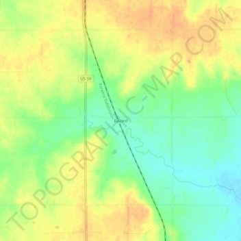
Name: Bayard topographic map, elevation, terrain.

Location: Bayard, Allen County, Kansas, United States (37.97364 -95.18303 38.01364 -95.14303)

Average elevation: 321 m

Minimum elevation: 301 m

Maximum elevation: 337 m

Other topographic maps

Click on a map to view its topography, its elevation and its terrain.

Moran

United States > Kansas > Allen County

Average elevation: 334 m

Mildred

United States > Kansas > Allen County

Average elevation: 321 m

Gear up for your next adventure:

🔋Solar Power Bank - Keep your GPS and devices charged during long outdoor trips
💡LED Headlamp - Hands-free illumination for night hiking and camping
🥾Mountain Hiking Shoes - Shoes with superior grip for mountainous terrain
🦯Trekking Poles - Reduced impact on joints for steep topographic climbs
🥽Outdoor Goggles - Protective eyewear for outdoor activities

As an Amazon Associate, this site earns from qualifying purchases at no extra cost to you.