
Make a donation
Gear up for your next adventure:
As an Amazon Associate, this site earns from qualifying purchases at no extra cost to you.
Monroe County topographic map
Click on the map to display elevation.
Make a donation
Gear up for your next adventure:
As an Amazon Associate, this site earns from qualifying purchases at no extra cost to you.
Monroe County
According to the Trewartha climate classification system, the higher elevation Pocono Plateau Region of Monroe County has a Temperate Continental climate (Dc) with warm summers (b), cold winters (o) and year-around precipitation (Dcbo). Dcbo climates are characterized by at least one month having an average mean temperature ≤ 32.0 °F (0.0 °C), four to seven months with an average mean temperature ≥ 50.0 °F (10.0 °C), all months with an average mean temperature < 72.0 °F (22.2 °C) and no significant precipitation difference between seasons. Although most summer days are comfortably humid on the Pocono Plateau, episodes of heat and high humidity can occur with heat index values > 92 °F (33 °C). Since 1981, the highest air temperature was 93.0 °F (33.9 °C) on July 15, 1995, and the highest daily average mean dew point was 70.8 °F (21.6 °C) on January 8, 2006. July is the peak month for thunderstorm activity which correlates with the average warmest month of the year. Since 1981, the wettest calendar day was 6.43 inches (163 mm) on September 30, 2010. During the winter months, the plant hardiness zone is 5b with an average annual extreme minimum air temperature of −11.2 °F (−24.0 °C). Since 1981, the coldest air temperature was −22.9 °F (−30.5 °C) on January 21, 1994. Episodes of extreme cold and wind can occur with wind chill values < −24 °F (−31 °C). The average snowiest month is January which correlates with the average coldest month of the year. Ice storms and large snowstorms depositing ≥ 12 inches (30 cm) of snow occur nearly every year, particularly during nor’easters from December through March.
Make a donation
Gear up for your next adventure:
As an Amazon Associate, this site earns from qualifying purchases at no extra cost to you.
About this map
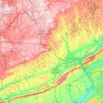
Name: Monroe County topographic map, elevation, terrain.
Location: Monroe County, Pennsylvania, United States (40.81484 -75.64929 41.25213 -74.96660)
Average elevation: 361 m
Minimum elevation: 56 m
Maximum elevation: 684 m
Make a donation
Gear up for your next adventure:
As an Amazon Associate, this site earns from qualifying purchases at no extra cost to you.
Other topographic maps
Click on a map to view its topography, its elevation and its terrain.
Feasterville
United States > Pennsylvania > Bucks County > Lower Southampton Township
Average elevation: 66 m
South Mountain
United States > Pennsylvania > Lehigh County > Upper Saucon
Unlike Blue Mountain to its north, South Mountain does not follow a straight geographic line. The mountain ranges in elevation between 500 and 1,300 feet (150 and 400 m) above sea level. The ridge is made of metamorphic rocks and gneiss, which date to the Precambrian era and range from about 570 million to…
Average elevation: 153 m
Blue Mountain
United States > Pennsylvania > Monroe County > Eldred Township
The ridge of Blue Mountain runs for 150 miles (240 km) through Pennsylvania, reaching an elevation of 2,270 feet (690 m) above sea level just north of the Pennsylvania Turnpike, near the borough of Newburg. Most of the ridgecrest, however, only reaches between 1,400 and 1,700 feet (430 and 520 m) in elevation.…
Average elevation: 241 m
Bullock-Pens Park
United States > Pennsylvania > Allegheny County > Pittsburgh
Average elevation: 338 m
Make a donation
Gear up for your next adventure:
As an Amazon Associate, this site earns from qualifying purchases at no extra cost to you.
West Pittsburg
United States > Pennsylvania > Lawrence County > Taylor Township
Average elevation: 279 m
Bridge Point
United States > Pennsylvania > Bucks County > Doylestown Township
Average elevation: 82 m
Make a donation
Gear up for your next adventure:
As an Amazon Associate, this site earns from qualifying purchases at no extra cost to you.
Pipersville
United States > Pennsylvania > Bucks County > Bedminster Township
Average elevation: 125 m
Baptist Hill
United States > Pennsylvania > Chester County > Tredyffrin Township
Average elevation: 102 m
Plain Nine Dam
United States > Pennsylvania > Blair County > Juniata Township
Average elevation: 550 m
Make a donation
Gear up for your next adventure:
As an Amazon Associate, this site earns from qualifying purchases at no extra cost to you.
Fern Glen
United States > Pennsylvania > Luzerne County > Black Creek Township
Average elevation: 391 m
Lower Makefield Township
United States > Pennsylvania > Bucks County > Lower Makefield Township
Average elevation: 44 m
Make a donation
Gear up for your next adventure:
As an Amazon Associate, this site earns from qualifying purchases at no extra cost to you.
Adams Run
United States > Pennsylvania > Bedford County > East Saint Clair Township
Average elevation: 361 m
Palomino Farms
United States > Pennsylvania > Bucks County > Warrington Township
Average elevation: 93 m
Make a donation
Gear up for your next adventure:
As an Amazon Associate, this site earns from qualifying purchases at no extra cost to you.
Grimesville
United States > Pennsylvania > Lycoming County > Old Lycoming Township
Average elevation: 203 m
Forestville
United States > Pennsylvania > Chester County > Upper Oxford Township
Average elevation: 150 m
Make a donation
Gear up for your next adventure:
As an Amazon Associate, this site earns from qualifying purchases at no extra cost to you.
Mount Davis
United States > Pennsylvania > Somerset County > Elk Lick Township
Mount Davis has a humid continental climate that is affected by the high elevation significantly enough that the area feels slightly more like a cooler version of the climate zone during the winter months. Due to its high elevation, the area is colder much of the winter than Altoona, Johnstown, or State…
Average elevation: 908 m
Blue Knob
United States > Pennsylvania > Bedford County > Pavia Township
Blue Knob (elevation 3,146 feet (959 m)) is a summit in the eastern United States with a broad dome that is the northernmost 3,000-footer in the Allegheny Mountains. It is the highest point in Bedford County, Pennsylvania.
Average elevation: 792 m
Make a donation
Gear up for your next adventure:
As an Amazon Associate, this site earns from qualifying purchases at no extra cost to you.
Make a donation
Gear up for your next adventure:
As an Amazon Associate, this site earns from qualifying purchases at no extra cost to you.
Mill Run
United States > Pennsylvania > Fayette County > Springfield Township
Average elevation: 482 m
Farquhar
United States > Pennsylvania > Washington County > Somerset Township
Average elevation: 322 m
Make a donation
Gear up for your next adventure:
As an Amazon Associate, this site earns from qualifying purchases at no extra cost to you.
Eakin Corner
United States > Pennsylvania > Venango County > Scrubgrass Township
Average elevation: 424 m
Doylestown
United States > Pennsylvania > Bucks County > Doylestown
An electric telegraph station was built in 1846, and the North Pennsylvania Railroad completed a branch to Doylestown in 1856. The first gas lights were introduced in 1854. Because of the town's relatively high elevation and a lack of strong water power, substantial industrial development never occurred and…
Average elevation: 100 m
Make a donation
Gear up for your next adventure:
As an Amazon Associate, this site earns from qualifying purchases at no extra cost to you.
Big Knob
United States > Pennsylvania > Beaver County > New Sewickley Township
Average elevation: 345 m
Lower Longswamp
United States > Pennsylvania > Longswamp Township > Longswamp > Lower Longswamp
Average elevation: 190 m
Make a donation
Gear up for your next adventure:
As an Amazon Associate, this site earns from qualifying purchases at no extra cost to you.
Rehrersburg
United States > Pennsylvania > Tulpehocken Township > Rehrersburg
Average elevation: 165 m
Thorndale
United States > Pennsylvania > Chester County > Caln Township > Thorndale
Average elevation: 129 m
Make a donation
Gear up for your next adventure:
As an Amazon Associate, this site earns from qualifying purchases at no extra cost to you.
Lester
United States > Pennsylvania > Delaware County > Tinicum Township > Lester
Average elevation: 5 m
Make a donation
Gear up for your next adventure:
As an Amazon Associate, this site earns from qualifying purchases at no extra cost to you.
Greenwood Village
United States > Pennsylvania > Butler County > Greenwood Village
Average elevation: 386 m
Norritonville
United States > Pennsylvania > Montgomery County > Worcester Township > Norritonville
Average elevation: 95 m
Acme
United States > Pennsylvania > Westmoreland County > Mount Pleasant Township > Acme
Average elevation: 585 m
Maplewood Terrace
United States > Pennsylvania > Westmoreland County > Hempfield Township > Maplewood Terrace
Average elevation: 346 m
Make a donation
Gear up for your next adventure:
As an Amazon Associate, this site earns from qualifying purchases at no extra cost to you.
Lisburn
United States > Pennsylvania > Cumberland County > Lower Allen > Lisburn
Average elevation: 142 m
Philadelphia
United States > Pennsylvania > Philadelphia County > Philadelphia
Average elevation: 35 m
Milford Park
United States > Pennsylvania > Lehigh County > Upper Milford Township > Milford Park
Average elevation: 221 m
Lawrence Park
United States > Pennsylvania > Dauphin County > Linglestown > Lawrence Park
Average elevation: 167 m
Make a donation
Gear up for your next adventure:
As an Amazon Associate, this site earns from qualifying purchases at no extra cost to you.
Mill Run
United States > Pennsylvania > Blair County > Altoona > Allegheny Furnace
Average elevation: 349 m
Hartzells Ferry
United States > Pennsylvania > Northampton County > Upper Mount Bethel Township > Hartzells Ferry
Average elevation: 144 m
Dale
United States > Pennsylvania > Berks County > Washington Township > Dale
Average elevation: 236 m
Southwest
United States > Pennsylvania > Westmoreland County > Mount Pleasant Township > Southwest
Average elevation: 336 m
Make a donation
Gear up for your next adventure:
As an Amazon Associate, this site earns from qualifying purchases at no extra cost to you.
Skunk Pond (Elevation 1100 feet)
United States > Pennsylvania > Westmoreland County > Murrysville
Average elevation: 323 m
Make a donation
Gear up for your next adventure:
As an Amazon Associate, this site earns from qualifying purchases at no extra cost to you.
Albrightsville
United States > Pennsylvania > Carbon County > Kidder Township
Average elevation: 498 m
Make a donation
Gear up for your next adventure:
As an Amazon Associate, this site earns from qualifying purchases at no extra cost to you.
Make a donation
Gear up for your next adventure:
As an Amazon Associate, this site earns from qualifying purchases at no extra cost to you.