Geolocate

Lugus topographic map

Click on the map to display elevation.

About this map

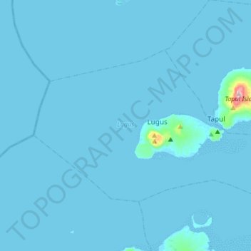
Name: Lugus topographic map, elevation, terrain.

Location: Lugus, Sulu, Zamboanga Peninsula, Philippines (5.61721 120.66384 5.77834 120.95417)

Average elevation: 7 m

Minimum elevation: -2 m

Maximum elevation: 467 m

Other topographic maps

Click on a map to view its topography, its elevation and its terrain.

Talipao

Philippines > Sulu

Average elevation: 138 m

Maimbung

Philippines > Sulu

Average elevation: 76 m

Jolo

Philippines > Sulu

Average elevation: 57 m

Bambannan Island

Philippines > Sulu

Average elevation: 0 m

Capual

Philippines > Sulu

Average elevation: 81 m

Luuk

Philippines > Sulu

Average elevation: 22 m

Old Panamao

Philippines > Sulu

Average elevation: 41 m

Parang

Philippines > Sulu

Average elevation: 47 m

Omar

Philippines > Sulu

Average elevation: 39 m

Seit Lake

Philippines > Sulu > Old Panamao

Average elevation: 14 m

Bangkilay

Philippines > Sulu > Pangutaran

Average elevation: 6 m

Mount Tayungan

Philippines > Sulu > Masjid Bayli

Average elevation: 158 m

North Ubian Island

Philippines > Sulu > Pangutaran

Average elevation: 2 m

Jolo

Philippines > Sulu

Average elevation: 57 m

Samal Island

Philippines > Sulu > Siasi

Average elevation: 3 m

Old Panamao

Philippines > Sulu

Average elevation: 41 m

Gear up for your next adventure:

🧭GPS Handheld Device - Reliable GPS navigation for outdoor adventures
🥾Approach Shoes - Shoes designed for climbing approaches and rugged trails
🧊Insulated Water Bottle - Keeps drinks cold in summer and prevents freezing in winter
🦶Anti-Blister Balm - Prevents friction and hotspots during long ascents
🛶Waterproof Dry Bags - Keep electronics and clothes dry during river crossings

As an Amazon Associate, this site earns from qualifying purchases at no extra cost to you.