Geolocate

Omar topographic map

Click on the map to display elevation.

About this map

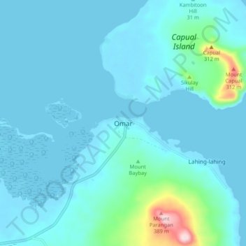
Name: Omar topographic map, elevation, terrain.

Location: Omar, Sulu, Zamboanga Peninsula, Philippines (5.96844 121.34775 6.04844 121.42775)

Average elevation: 39 m

Minimum elevation: -1 m

Maximum elevation: 383 m

Other topographic maps

Click on a map to view its topography, its elevation and its terrain.

Lugus Island

Philippines > Sulu

Average elevation: 20 m

Bambannan Island

Philippines > Sulu

Average elevation: 0 m

Dammi Island

Philippines > Sulu

Average elevation: 0 m

Siasi

Philippines > Sulu

Average elevation: 7 m

Seit Lake

Philippines > Sulu > Old Panamao

Average elevation: 14 m

Jolo Island

Philippines > Sulu

Average elevation: 28 m

North Ubian Island

Philippines > Sulu > Pangutaran

Average elevation: 2 m

Kulassian Island

Philippines > Sulu > Pangutaran

Average elevation: 0 m

Simisa Island

Philippines > Sulu > Banguingui

Average elevation: 2 m

Patikul

Philippines > Sulu

Average elevation: 50 m

Siasi Island

Philippines > Sulu > Siasi

Average elevation: 47 m

Pangutaran

Philippines > Sulu

Average elevation: 4 m

Siasi

Philippines > Sulu

Average elevation: 7 m

Gear up for your next adventure:

🧰Multitool Knife - Compact and versatile tool for outdoor use
🥾Hiking Leggings - Comfortable leggings for outdoor activities
🎒Hiking Backpack - Lightweight and ergonomic backpacks for day hikes or multi-day treks
🛶Canoe Life Vest - Safety vest for water sports
🎒Fully Waterproof Backpack - Total protection for photography gear and electronics

As an Amazon Associate, this site earns from qualifying purchases at no extra cost to you.