Geolocate

Parang topographic map

Click on the map to display elevation.

About this map

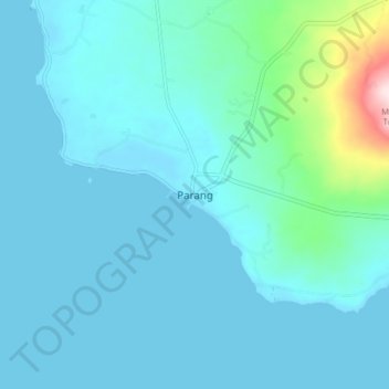
Name: Parang topographic map, elevation, terrain.

Location: Parang, Sulu, Zamboanga Peninsula, Philippines (5.87387 120.86696 5.95387 120.94696)

Average elevation: 47 m

Minimum elevation: 0 m

Maximum elevation: 421 m

Other topographic maps

Click on a map to view its topography, its elevation and its terrain.

Lugus Island

Philippines > Sulu

Average elevation: 20 m

Bambannan Island

Philippines > Sulu

Average elevation: 0 m

Dammi Island

Philippines > Sulu

Average elevation: 0 m

Lugus

Philippines > Sulu

Average elevation: 7 m

Siasi

Philippines > Sulu

Average elevation: 7 m

Seit Lake

Philippines > Sulu > Old Panamao

Average elevation: 14 m

North Ubian Island

Philippines > Sulu > Pangutaran

Average elevation: 2 m

Simisa Island

Philippines > Sulu > Banguingui

Average elevation: 2 m

Kulassian Island

Philippines > Sulu > Pangutaran

Average elevation: 0 m

Jolo Island

Philippines > Sulu

Average elevation: 28 m

Patikul

Philippines > Sulu

Average elevation: 50 m

Pangutaran

Philippines > Sulu

Average elevation: 4 m

Siasi Island

Philippines > Sulu > Siasi

Average elevation: 47 m

Siasi

Philippines > Sulu

Average elevation: 7 m

Gear up for your next adventure:

🪑Ultralight Camping Stool - Compact seating for rest stops during long hikes
💧Hydration Pack - Hands-free hydration system for long hikes
🧦Hiking Liner Socks - Thin base layer to prevent friction and blisters
🥾Approach Boots - Comfortable boots for hiking and climbing approaches
🔪Outdoor Multitool - Versatile tool for repairs and food prep in the wild

As an Amazon Associate, this site earns from qualifying purchases at no extra cost to you.