Geolocate

Samal Island topographic map

Click on the map to display elevation.

About this map

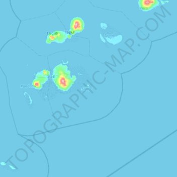
Name: Samal Island topographic map, elevation, terrain.

Location: Samal Island, Siasi, Sulu, Zamboanga Peninsula, Philippines (5.18000 120.63000 5.82000 121.27000)

Average elevation: 3 m

Minimum elevation: -1 m

Maximum elevation: 468 m

Other topographic maps

Click on a map to view its topography, its elevation and its terrain.

Siasi Island

Philippines > Sulu > Siasi

Average elevation: 47 m

Gear up for your next adventure:

🥾Hiking Shorts - Breathable shorts suitable for summer hikes
🕶️Polarized Sunglasses - Reduces glare from snow and water at high elevations
Camping Groundsheet - Protect your tent from moisture and dirt
🔭Compact Binoculars - Lightweight optics for scouting trails and wildlife
🛌Down Sleeping Bag - Superior warmth-to-weight ratio for cold nights

As an Amazon Associate, this site earns from qualifying purchases at no extra cost to you.