Geolocate

Bihor topographic map

Click on the map to display elevation.

About this map

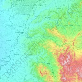
Name: Bihor topographic map, elevation, terrain.

Location: Bihor, Romania (46.38505 21.42762 47.60010 22.81958)

Average elevation: 312 m

Minimum elevation: 83 m

Maximum elevation: 1,820 m

Other topographic maps

Click on a map to view its topography, its elevation and its terrain.

Coruia

Romania > Maramureș

Average elevation: 201 m

Chechiș

Romania > Sălaj

Average elevation: 285 m

Doman

Romania > Caraș-Severin > Reșița

Average elevation: 437 m

Cornu

Romania > Prahova

Average elevation: 492 m

Rânca

Romania > Gorj

Average elevation: 1,472 m

Sebeș

Romania > Brașov

Average elevation: 564 m

Obârșia Lotrului

Romania > Vâlcea > Voineasa

Average elevation: 1,500 m

Eremieni

Romania > Mureș

Average elevation: 452 m

Bâsca Chiojdului

Romania > Buzău

Average elevation: 732 m

Bucharest

Romania > Bucharest > Bucharest

Average elevation: 82 m

Moeciu de Jos

Romania > Brașov > Moeciu de Jos

Average elevation: 900 m

Toplița

Romania > Hunedoara > Toplița

Average elevation: 565 m

Satu Mare

Romania > Satu Mare > Satu Mare

Average elevation: 128 m

Cenad

Romania > Timiș > Cenad

Average elevation: 86 m

Baneasa

Romania > Constanța > Baneasa

Average elevation: 128 m

Galați

Romania > Galați > Galați

Galați is located in southeastern Romania. Its coordinates are latitude 45 ° 27 'north and longitude 28 ° 02' east. Its area is 246.4 square kilometers (95.1 sq mi). Galați lies in the southern part of the Moldavian Plateau on the left (west) bank of the Danube river at the junction of the Siret River…

Average elevation: 33 m

Tudor Vladimirescu

Romania > Tulcea > Tulcea

Average elevation: 15 m

Nămaș

Romania > Alba > Nămaș

Average elevation: 790 m

Padiș

Romania > Bihor > Padiș

Average elevation: 1,332 m

Batăr

Romania > Bihor > Batăr

Average elevation: 103 m

Transylvania

Romania > Mureș > Band

Average elevation: 648 m

Miercurea Ciuc

Romania > Harghita > Miercurea Ciuc

Average elevation: 689 m

Pătârș

Romania > Arad

Average elevation: 242 m

Gear up for your next adventure:

🧢Beanie Hat - Keep your head warm in cold weather
🥾Mountain Hiking Boots - High-traction boots for rocky terrain
🧥Waterproof Pants - Keep dry during rainy hiking conditions
🏃Hydration Running Vest - Carry water and maps close to your body for speed
🧣Merino Neck Gaiter - Protects against wind, sun, and cold at high altitudes

As an Amazon Associate, this site earns from qualifying purchases at no extra cost to you.