Geolocate

Transylvania topographic map

Click on the map to display elevation.

About this map

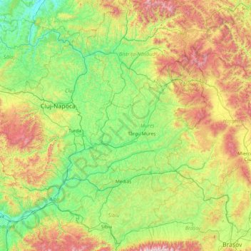
Name: Transylvania topographic map, elevation, terrain.

Location: Transylvania, Band, Mureș, 547065, Romania (45.59716 23.37403 47.59716 25.37403)

Average elevation: 648 m

Minimum elevation: 155 m

Maximum elevation: 2,459 m

Gear up for your next adventure:

🔦LED Headlamp - Hands-free lighting for early morning starts or late finishes
Backpacking Tent - Lightweight tent for long-distance hiking trips
Family Camping Tent - Spacious tent suitable for family camping trips
💧Filtered Water Bottle - Safe drinking water on the go
🔋Lithium AA Batteries - Long-lasting power that performs in extreme cold

As an Amazon Associate, this site earns from qualifying purchases at no extra cost to you.