Geolocate

Eremieni topographic map

Click on the map to display elevation.

About this map

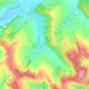
Name: Eremieni topographic map, elevation, terrain.

Location: Eremieni, Bereni, Mureș, 547391, Romania (46.51642 24.85158 46.55642 24.89158)

Average elevation: 452 m

Minimum elevation: 357 m

Maximum elevation: 581 m

Other topographic maps

Click on a map to view its topography, its elevation and its terrain.

Band

Romania > Mureș

Average elevation: 377 m

Târgu Mureș

Romania > Mureș

The old City Hall was built in 1906–1907 after the construction plans of Márcell Komor and Dezső Jakab. The entrance area, including the corridor and the staircase leading to the first floor, is the most representative in this regard. The ribbed stellar vaults that cover this area were inspired by Gothic…

Average elevation: 357 m

Bereni

Romania > Mureș

Average elevation: 465 m

Gear up for your next adventure:

🦌Outdoor Trail Camera - Monitor wildlife activity near your favorite spots
🔦LED Headtorch - Bright and durable light for night activities
🍽️Titanium Camping Spork - Ultralight and indestructible eating utensil
🧢Outdoor Cap - Protective cap for sun and rain during hikes
🥾Hiking Boots - Sturdy boots providing ankle support and traction on rugged trails

As an Amazon Associate, this site earns from qualifying purchases at no extra cost to you.