Geolocate

Satu Mare topographic map

Click on the map to display elevation.

About this map

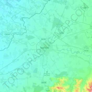
Name: Satu Mare topographic map, elevation, terrain.

Location: Satu Mare, 440014, Romania (47.62918 22.71256 47.94918 23.03256)

Average elevation: 128 m

Minimum elevation: 112 m

Maximum elevation: 274 m

Gear up for your next adventure:

🥽Outdoor Goggles - Protective eyewear for outdoor activities
🧼Biodegradable Camp Soap - Environmentally friendly cleaning for gear and body
🎒Backpack Rain Cover - External shield to keep your entire pack dry
🧢Outdoor Cap - Protective cap for sun and rain during hikes
Backpacking Tent - Lightweight tent for long-distance hiking trips

As an Amazon Associate, this site earns from qualifying purchases at no extra cost to you.