
Rânca topographic map
Click on the map to display elevation.
About this map
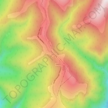
Name: Rânca topographic map, elevation, terrain.
Location: Rânca, Baia de Fier, Gorj, Romania (45.27211 23.66891 45.31211 23.70891)
Average elevation: 1,472 m
Minimum elevation: 1,016 m
Maximum elevation: 1,831 m
Other topographic maps
Click on a map to view its topography, its elevation and its terrain.
Novaci
Only 12 km (7.5 mi) from Novaci, passing the Transalpina (DN67C) road is Rânca (1,600 m (5,200 ft) altitude), a newly developed resort surrounded by mountain peaks and tremendous beauty. From this place is a view of the Parângu Mare peak and when the weather is good you can see the Peleaga peak of the…
Average elevation: 1,056 m