
Armstrong Lake topographic map
Click on the map to display elevation.
About this map
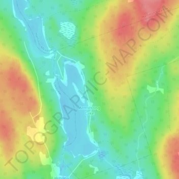
Name: Armstrong Lake topographic map, elevation, terrain.
Average elevation: 208 m
Minimum elevation: 175 m
Maximum elevation: 253 m
Municipality of the County of Kings trails, hiking, mountain biking, running and outdoor activities
Other topographic maps
Click on a map to view its topography, its elevation and its terrain.
Annapolis Valley
Canada > Nova Scotia > Municipality of the County of Kings > Auburn
Average elevation: 77 m
Starrs Point
Canada > Nova Scotia > Municipality of the County of Kings > Port Williams
Average elevation: 3 m
Gaspereau Mountain
Canada > Nova Scotia > Municipality of the County of Kings > Forest Hill
Average elevation: 185 m
Loon Lake Channel
Canada > Nova Scotia > Municipality of the County of Kings > Aylesford Lake
Average elevation: 220 m
Gaspereau
Canada > Nova Scotia > Municipality of the County of Kings > Gaspereau
Average elevation: 95 m
Cape Split
Canada > Nova Scotia > Municipality of the County of Kings > Scots Bay
Average elevation: 6 m
Horseshoe Meadows
Canada > Nova Scotia > Municipality of the County of Kings > Lake George
Average elevation: 220 m