
Margaree Harbour topographic map
Interactive map
Click on the map to display elevation.
About this map
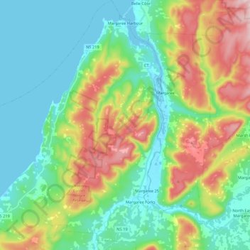
Name: Margaree Harbour topographic map, elevation, terrain.
Average elevation: 108 m
Minimum elevation: -1 m
Maximum elevation: 350 m
Other topographic maps
Click on a map to view its topography, its elevation and its terrain.
Meat Cove
Canada > Nova Scotia > Municipality of the County of Inverness > Meat Cove
Average elevation: 117 m
Upper Glencoe
Canada > Nova Scotia > Municipality of the County of Inverness > Glencoe
Average elevation: 181 m
Long Point Provincial Park
Canada > Nova Scotia > Municipality of the County of Inverness > Long Point
Average elevation: 32 m
Hawleys Hill
Canada > Nova Scotia > Municipality of the County of Inverness > Mabou
Average elevation: 90 m