Geolocate

Truro topographic map

Click on the map to display elevation.

About this map

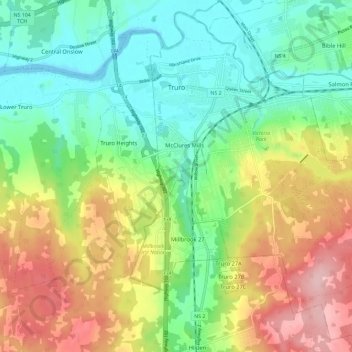
Name: Truro topographic map, elevation, terrain.

Location: Truro, Town of Truro, Colchester County, Nova Scotia, Canada (45.30842 -63.30863 45.38406 -63.19335)

Average elevation: 71 m

Minimum elevation: -2 m

Maximum elevation: 185 m

Town of Truro trails, hiking, mountain biking, running and outdoor activities

Other topographic maps

Click on a map to view its topography, its elevation and its terrain.

Victoria Park

Canada > Nova Scotia > Town of Truro > Truro

Average elevation: 58 m

McClures Mills

Canada > Nova Scotia > Town of Truro > Truro

Average elevation: 46 m

Victoria Park

Canada > Nova Scotia > Town of Truro > Truro

Average elevation: 58 m

Harmony Road

Canada > Nova Scotia > Town of Truro > Truro

Average elevation: 127 m

Victoria Park

Canada > Nova Scotia > Town of Truro > Truro

Average elevation: 58 m

Victoria Park

Canada > Nova Scotia > Town of Truro > Truro

Average elevation: 58 m

Gear up for your next adventure:

🥾Light Hiking Boots - Lightweight and comfortable boots for day hikes
🧥Ultralight Puffy Jacket - Maximum warmth that packs down to the size of an orange
🧢Sun Protection Cap - Breathable cap to protect from sun exposure
🧢Hiking Hat - Sun-protective and breathable hats for long treks
🥾Trekking Poles - Adjustable trekking poles to reduce knee stress and improve stability

As an Amazon Associate, this site earns from qualifying purchases at no extra cost to you.