Geolocate

Cuorgnè topographic map

Click on the map to display elevation.

About this map

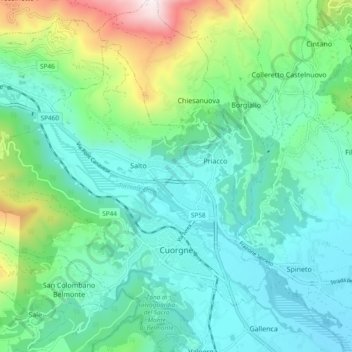
Name: Cuorgnè topographic map, elevation, terrain.

Location: Cuorgnè, Turin, Piedmont, 10082, Italy (45.37860 7.58095 45.42855 7.67523)

Average elevation: 580 m

Minimum elevation: 334 m

Maximum elevation: 1,396 m

Other topographic maps

Click on a map to view its topography, its elevation and its terrain.

Magnoletto

Italy > Piedmont > Turin > Condove

Average elevation: 699 m

Pratobotrile

Italy > Piedmont > Turin > Condove

Average elevation: 1,117 m

Turin

Italy > Piedmont > Turin

Average elevation: 295 m

Turin

Italy > Piedmont > Turin

Average elevation: 295 m

Rivetto

Italy > Piedmont > Turin > San Giorio di Susa

Average elevation: 583 m

Famolasco

Italy > Piedmont > Turin

Average elevation: 508 m

Morelli

Italy > Piedmont > Turin > Gravere

Average elevation: 785 m

La Cialma

Italy > Piedmont > Turin > Locana

Average elevation: 1,705 m

Tornetti

Italy > Piedmont > Turin > Viù

Average elevation: 1,333 m

Baio Dora

Italy > Piedmont > Turin

Average elevation: 494 m

Turin

Italy > Piedmont > Turin

Average elevation: 295 m

Belvedere

Italy > Piedmont > Turin > Borgiallo

Average elevation: 733 m

Gear up for your next adventure:

🔦LED Flashlight - Powerful and long-lasting flashlight for camping and emergencies
🛁Quick-Dry Microfiber Towel - Space-saving towel that dries rapidly on the move
Camping Coffee Maker - Brew fresh coffee anywhere on the topographic map
🧢Beanie Hat - Keep your head warm in cold weather
🛏️Sleeping Bag - Warm and compact sleeping bags for outdoor camping

As an Amazon Associate, this site earns from qualifying purchases at no extra cost to you.