Geolocate

Prarotto topographic map

Click on the map to display elevation.

About this map

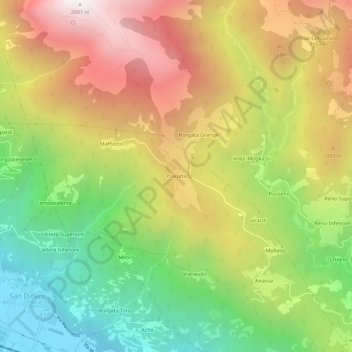
Name: Prarotto topographic map, elevation, terrain.

Location: Prarotto, Condove, Turin, Piedmont, Italy (45.12890 7.21693 45.16890 7.25693)

Average elevation: 1,190 m

Minimum elevation: 401 m

Maximum elevation: 2,080 m

Gear up for your next adventure:

Camping Coffee Maker - Brew fresh coffee anywhere on the topographic map
🥾Trail Hiking Boots - Supportive boots for rough trails
🧥Thermal Layer - Insulating layer for cold outdoor conditions
Family Camping Tent - Spacious tent suitable for family camping trips
🧦Hiking Socks - Moisture-wicking and comfortable socks for long hikes

As an Amazon Associate, this site earns from qualifying purchases at no extra cost to you.