Geolocate

Cavoretto topographic map

Click on the map to display elevation.

About this map

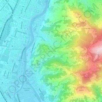
Name: Cavoretto topographic map, elevation, terrain.

Location: Cavoretto, Turin, Torino, Piedmont, 10133, Italy (45.00944 7.66849 45.04944 7.70849)

Average elevation: 337 m

Minimum elevation: 217 m

Maximum elevation: 657 m

Gear up for your next adventure:

👟Sport Hiking Sandals - Breathable footwear for water crossings and camp rest
💡LED Camping Lantern - Illuminate your campsite with long-lasting lanterns
🧥Waterproof Pants - Keep dry during rainy hiking conditions
🔋Lithium AA Batteries - Long-lasting power that performs in extreme cold
🧰Multitool Knife - Compact and versatile tool for outdoor use

As an Amazon Associate, this site earns from qualifying purchases at no extra cost to you.