Geolocate

Tobermory topographic map

Click on the map to display elevation.

About this map

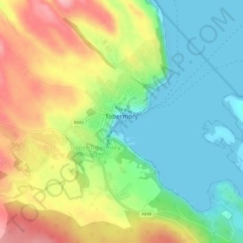
Name: Tobermory topographic map, elevation, terrain.

Location: Tobermory, Argyll and Bute, Scotland, United Kingdom (56.61286 -6.08027 56.63155 -6.06079)

Average elevation: 58 m

Minimum elevation: -1 m

Maximum elevation: 145 m

Other topographic maps

Click on a map to view its topography, its elevation and its terrain.

Ling

United Kingdom > Scotland > Argyll and Bute

Average elevation: 29 m

Ardbeg

United Kingdom > Scotland > Argyll and Bute

Average elevation: 31 m

Dunoon

United Kingdom > Scotland > Argyll and Bute

Average elevation: 98 m

Sandbank

United Kingdom > Scotland > Argyll and Bute

Average elevation: 100 m

Iona

United Kingdom > Scotland > Argyll and Bute > The Village

Average elevation: 9 m

Tiree

United Kingdom > Scotland > Argyll and Bute > Balevullin

Average elevation: 3 m

Loch Etive

United Kingdom > Scotland > Argyll and Bute > Connel

Average elevation: 318 m

Gear up for your next adventure:

🧥Fleece Jacket - Warm and lightweight jacket for layering
🥾Lightweight Hiking Boots - Boots for comfort and mobility on long hikes
🥾Lightweight Hiking Shoes - Comfortable shoes for day hikes
🦌Outdoor Trail Camera - Monitor wildlife activity near your favorite spots
🥾Trail Running Shoes - Lightweight and durable shoes for trail running

As an Amazon Associate, this site earns from qualifying purchases at no extra cost to you.