
Chapelton of Elsick topographic map
Interactive map
Click on the map to display elevation.
Chapelton of Elsick
House styles in Chapelton vary from small apartments to five bedroom family homes. The architecture of the houses' exteriors have slate roof tiles and lime harl. Architectural details and materials in the first phase include slate roofs, timber windows (sash and case to public elevations), Dormer|dormer windows, timber linings to some extensions and garages, corrugated metal roofing, and some properties have working chimneys for wood-burning stoves. A small number of timber buildings with a modern feel are incorporated around the neighbourhood edge.
About this map
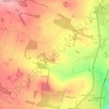
Name: Chapelton of Elsick topographic map, elevation, terrain.
Location: Chapelton of Elsick, Aberdeenshire, Scotland, United Kingdom (57.02877 -2.20901 57.06096 -2.16113)
Average elevation: 93 m
Minimum elevation: 4 m
Maximum elevation: 138 m
Other topographic maps
Click on a map to view its topography, its elevation and its terrain.
Braemar
United Kingdom > Scotland > Aberdeenshire
Braemar /breɪˈmɑːr/ is a village in Aberdeenshire, Scotland, around 58 miles (93 km) west of Aberdeen in the Highlands. It is the closest significantly-sized settlement to the upper course of the River Dee, sitting at an elevation of 339 metres (1,112 ft).
Average elevation: 445 m
Ballater
United Kingdom > Scotland > Aberdeenshire > Ballater
Ballater (/ˈbælətər/, Scottish Gaelic: Bealadair) is a village in Aberdeenshire, Scotland on the River Dee, immediately east of the Cairngorm Mountains. Situated at an elevation of 213 metres (699 feet), Ballater is a centre for hikers and known for its spring water, once said to cure scrofula. It is home…
Average elevation: 360 m