Geolocate

Kuruva Island topographic map

Click on the map to display elevation.

About this map
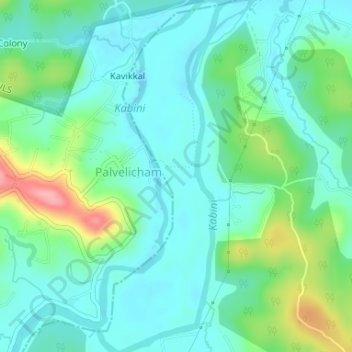
Name: Kuruva Island topographic map, elevation, terrain.

Location: Kuruva Island, Sulthanbathery, Wayanad District, Kerala, India (11.80550 76.08514 11.83762 76.09906)

Average elevation: 733 m

Minimum elevation: 704 m

Maximum elevation: 817 m

Other topographic maps

Click on a map to view its topography, its elevation and its terrain.

Sultan Bathery

India > Kerala > Sulthanbathery

Sulthan Bathery is located at 11°40′N 76°17′E / 11.67°N 76.28°E / 11.67; 76.28. It has an average elevation of 907 m (2,976 ft).

Average elevation: 876 m

Seethamount

India > Kerala > Sulthanbathery > Kabanigiri

Average elevation: 731 m

Edakkal

India > Kerala > Sulthanbathery > Ambalavayal

Average elevation: 927 m

Kenichira

India > Kerala > Sulthanbathery

Average elevation: 788 m

Muthanga

India > Kerala > Sulthanbathery

Average elevation: 866 m

Koliyadi

India > Kerala > Sulthanbathery

Average elevation: 886 m

Sulthan Bathery

India > Kerala > Sulthanbathery > Sultan Bathery

Average elevation: 873 m

Marakavu

India > Kerala > Sulthanbathery > Pulpally

Average elevation: 769 m

Kenichira

India > Kerala > Sulthanbathery

Average elevation: 770 m

Nellarachal

India > Kerala > Sulthanbathery

Average elevation: 781 m

Vadakkanad

India > Kerala > Sulthanbathery

Average elevation: 896 m

Kalluvayal

India > Kerala > Sulthanbathery > Pulpally

Average elevation: 816 m

Nadavayal

India > Kerala > Sulthanbathery

Average elevation: 751 m

Ambalavayal

India > Kerala > Sulthanbathery

Average elevation: 880 m

Meenangadi

India > Kerala > Sulthanbathery

Average elevation: 760 m

Kolagappara

India > Kerala > Sulthanbathery

Average elevation: 795 m

Pazhoor

India > Kerala > Sulthanbathery

Average elevation: 881 m

Kalluvayal

India > Kerala > Sulthanbathery > Pulpally

Average elevation: 816 m

Poothadi

India > Kerala > Sulthanbathery

Average elevation: 742 m

Pulpally

India > Kerala > Sulthanbathery

Average elevation: 781 m

Ambalavayal

India > Kerala > Sulthanbathery

Average elevation: 880 m

Sultan Bathery

India > Kerala > Sulthanbathery

Sulthan Bathery is located at 11°40′N 76°17′E / 11.67°N 76.28°E / 11.67; 76.28. It has an average elevation of 907 m (2,976 ft).

Average elevation: 876 m
Meenangadi

India > Kerala > Sulthanbathery

Average elevation: 760 m

Paplassery

India > Kerala > Sulthanbathery

Average elevation: 795 m

Sultan Bathery

India > Kerala > Sulthanbathery

Sultan Bathery is located at 11°40′N 76°17′E / 11.67°N 76.28°E / 11.67; 76.28, on the Kozhikode–Kollegal National Highway (NH 766) 97 kilometers from Kozhikode. It is 114 km from Mysore and about 100 km from Ooty (Udagamandalam). It is also connected with Nilambur. It has an average…

Average elevation: 876 m

Sulthan Bathery

India > Kerala > Sulthanbathery > Sultan Bathery

Average elevation: 873 m

Muthanga

India > Kerala > Sulthanbathery

Average elevation: 866 m

Gear up for your next adventure:

🪜Heavy Duty Carabiners - Multi-use clips for securing gear to your backpack
🧥Waterproof Pants - Keep dry during rainy hiking conditions
🥾Hiking Gaiters - Protect legs and shoes from mud, snow, and debris
🥾Trekking Poles - Adjustable trekking poles to reduce knee stress and improve stability
🛶Kayak Dry Bag - Waterproof storage for kayaking adventures

As an Amazon Associate, this site earns from qualifying purchases at no extra cost to you.