Geolocate

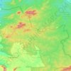
Edakkal Caves topographic map

Click on the map to display elevation.

About this map

Name: Edakkal Caves topographic map, elevation, terrain.

Location: Edakkal Caves, Sultan Bathery, Sulthanbathery, Wayanad, Kerala, 633593, India (11.62088 76.22067 11.64088 76.24067)

Average elevation: 917 m

Minimum elevation: 790 m

Maximum elevation: 1,185 m

Other topographic maps

Click on a map to view its topography, its elevation and its terrain.
Sulthan Bathery

India > Kerala > Sulthanbathery > Sultan Bathery

Average elevation: 873 m

Sulthan Bathery

India > Kerala > Sulthanbathery > Sultan Bathery

Average elevation: 873 m

Gear up for your next adventure:

⛺Tent Footprint - Protect tent floor and increase durability
🧦Thermal Socks - Warm socks for winter hiking or camping
💡Solar Camping Lamp - Eco-friendly lighting for campsites
🥾All-Terrain Hiking Boots - Versatile boots for varied hiking conditions
🧣Merino Neck Gaiter - Protects against wind, sun, and cold at high altitudes

As an Amazon Associate, this site earns from qualifying purchases at no extra cost to you.