
Yazd Province topographic map
Interactive map
Click on the map to display elevation.
About this map
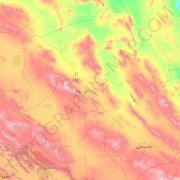
Name: Yazd Province topographic map, elevation, terrain.
Location: Yazd Province, Iran (29.60040 52.80050 33.38247 56.65456)
Average elevation: 1,633 m
Minimum elevation: 614 m
Maximum elevation: 3,918 m
Other topographic maps
Click on a map to view its topography, its elevation and its terrain.
Amlash
Iran > Gilan Province > Amlash County > دهستان املش شمالی
Amlash (Persian: املش) is a city in the Central District of Amlash County, Gilan province, in northwestern Iran, serving as the capital of both the county and the district. Amlash sits at an altitude of 13 metres (45 feet).
Average elevation: 66 m
پایین شالینگچال
Iran > Mazandaran Province > Babol County > دهستان فیروزجاه
Average elevation: 2,077 m
Damavand
Iran > Mazandaran Province > Amol County > دهستان لاریجان سفلی
Mount Damavand (Persian: دماوند [dæmɒːvænd] ) is a dormant stratovolcano and is the highest peak in Iran and Western Asia, the highest volcano in Asia, and the 3rd highest volcano in the Eastern Hemisphere (after Mount Kilimanjaro and Mount Elbrus), at an elevation of 5,609 metres (18,402 ft).…
Average elevation: 4,949 m
Sabalan
Iran > Ardabil Province > Meshkinshahr County > دهستان لاهرود
At 4,794 metres (15,728 ft) in elevation, it is the third-highest mountain in Iran. It has a permanent crater lake formed at its summit. On one of its slopes around 3,600 metres (11,800 ft) in elevation there are large rock formations of eroded volcanic outcrops that resemble animals, birds, and insects.
Average elevation: 4,281 m
Zard Kuh
Iran > Chaharmahal and Bakhtiyari Province > Kuhrang County > شهریاری
Average elevation: 3,808 m
Qinarjeh, Takab
Iran > West Azerbaijan Province > Takab County > Qinarjeh, Takab
Average elevation: 2,334 m
Kerman
Iran > Kerman Province > Kerman
Kerman is located on a high margin of Kavir-e Lut (Lut Desert) in the south-central part of Iran. The city is surrounded by mountains. Kerman is also located along the Saheb Al Zman mountain. The city is 1,755 m (5,758 ft) above sea level, making it third in elevation among provincial capitals in Iran. Winter…
Average elevation: 1,821 m
Qom
Iran > Qom Province > Qom
The city's topography in the 10th century still reflected the evolutionary merging of the original six villages; these were still separated by fields. The town center was located in the village of Mamajjān, which was connected to other parts of the city on the other side of the river by four bridges. There…
Average elevation: 959 m
Tabriz
Iran > East Azerbaijan Province > Tabriz
Tabriz (Persian: تبریز (listen); Azerbaijani: تبریز) is the most populated city in northwestern Iran, one of the historical capitals of Iran and the present capital of East Azerbaijan province. It is the sixth most populous city in Iran. Located in the Quru River valley, in Iran's historic…
Average elevation: 1,594 m
Khorramabad
Khorramabad has what is classed under the Köppen climate classification as a Hot-summer Mediterranean climate (Csa) climate. Its elevation is 1147.8 above sea level. Average annual precipitation is 511.06 and its average annual temperature is 17.21 Celsius.
Average elevation: 1,527 m
بلهزار
Iran > Kohgiluye and Buyer Ahmad Province > دهستان سررودشمالی > بلهزار
Average elevation: 1,877 m
Khanabad
Iran > Markazi Province > Khoshkrud Rural District (Markazi Province) > Khanabad
Average elevation: 1,460 m
Kashan
Iran > East Azerbaijan Province > دهستان گویجه بل > Kashan
Kashan has a cold desert climate with cold winters (although warmer than other Iranian cities) and hot, sometimes very hot summers. Kashan is significantly warmer than other cities in the Iranian Plateau due to its lower elevation. Its climate is somewhat similar to Qom.
Average elevation: 1,416 m