Geolocate

Amlash topographic map

Click on the map to display elevation.

Amlash

Amlash (Persian: املش) is a city in the Central District of Amlash County, Gilan province, in northwestern Iran, serving as the capital of both the county and the district. Amlash sits at an altitude of 13 metres (45 feet).

Wikipedia (CC-BY-SA 3.0)

About this map

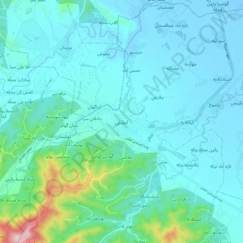
Name: Amlash topographic map, elevation, terrain.

Location: Amlash, دهستان املش شمالی, بخش مرکزی, Amlash County, Gilan Province, Iran (37.05619 50.14445 37.13619 50.22445)

Average elevation: 66 m

Minimum elevation: -14 m

Maximum elevation: 492 m

Gear up for your next adventure:

🥫Freeze-Dried Meals - Lightweight, high-calorie nutrition for multi-day treks
🥾Hiking Leggings - Comfortable leggings for outdoor activities
🧥Insulated Jacket - Keep warm in cold outdoor conditions
🧭GPS Handheld Device - Reliable GPS navigation for outdoor adventures
🍽️Titanium Camping Spork - Ultralight and indestructible eating utensil

As an Amazon Associate, this site earns from qualifying purchases at no extra cost to you.