Geolocate

Sabalan topographic map

Click on the map to display elevation.

Sabalan

At 4,794 metres (15,728 ft) in elevation, it is the third-highest mountain in Iran. It has a permanent crater lake formed at its summit. On one of its slopes around 3,600 metres (11,800 ft) in elevation there are large rock formations of eroded volcanic outcrops that resemble animals, birds, and insects.

Wikipedia (CC-BY-SA 3.0)

About this map

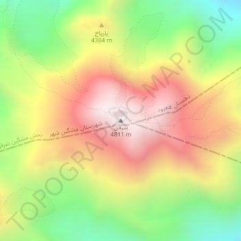
Name: Sabalan topographic map, elevation, terrain.

Location: Sabalan, دهستان لاهرود, بخش مشگین شرقی, Meshkinshahr County, Ardabil Province, Iran (38.26688 47.83675 38.26698 47.83685)

Average elevation: 4,281 m

Minimum elevation: 3,756 m

Maximum elevation: 4,802 m

Gear up for your next adventure:

🧴Outdoor Sunscreen - High SPF protection for high-altitude UV exposure
🔦LED Headlamp - Hands-free lighting for early morning starts or late finishes
🥾Light Hiking Boots - Lightweight and comfortable boots for day hikes
🔦UV Flashlight - Detect minerals or specific insects in the dark
🧴First Aid Kit - Essential first aid supplies for outdoor emergencies

As an Amazon Associate, this site earns from qualifying purchases at no extra cost to you.