
Kenton County topographic map
Interactive map
Click on the map to display elevation.
About this map
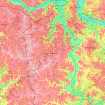
Name: Kenton County topographic map, elevation, terrain.
Location: Kenton County, Kentucky, United States (38.78969 -84.62370 39.09992 -84.41749)
Average elevation: 233 m
Minimum elevation: 135 m
Maximum elevation: 293 m
Other topographic maps
Click on a map to view its topography, its elevation and its terrain.
Louisville
United States > Kentucky > Jefferson County
Louisville, Jefferson County, Kentucky, United States
Average elevation: 188 m
Zion Hill
United States > Kentucky > Scott County
Zion Hill, Scott County, Kentucky, United States
Average elevation: 260 m
Confluence
United States > Kentucky > Leslie County
Confluence, Leslie County, Kentucky, United States
Average elevation: 336 m
Hopkinsville
United States > Kentucky > Christian County
Hopkinsville, Christian County, Kentucky, 42240, United States
Average elevation: 171 m
Robinson Creek
United States > Kentucky > Pike County
Robinson Creek, Pike County, Kentucky, 41560, United States
Average elevation: 337 m
Crittenden County
Crittenden County, Kentucky, United States
Average elevation: 141 m
Redhouse
United States > Kentucky > Madison County
Redhouse, Madison County, Kentucky, United States
Average elevation: 248 m
New
United States > Kentucky > Owen County
New, Owen County, Kentucky, United States
Average elevation: 243 m
Horse Cave
United States > Kentucky > Hart County
Horse Cave, Hart County, Kentucky, United States
Average elevation: 207 m
Winchester
United States > Kentucky > Clark County
Winchester, Clark County, Kentucky, United States
Average elevation: 296 m
Bardstown
United States > Kentucky > Nelson County
Bardstown, Nelson County, Kentucky, 40004, United States
Average elevation: 199 m
Eastern
United States > Kentucky > Floyd County
Eastern, Floyd County, Kentucky, 41622, United States
Average elevation: 274 m
Lynch
United States > Kentucky > Harlan County
Lynch, Harlan County, Kentucky, United States
Average elevation: 770 m
Pikeville
United States > Kentucky > Pike County
Pikeville, Pike County, Kentucky, United States
Average elevation: 338 m
Mullins Point
United States > Kentucky > Wolfe County
Mullins Point, Wolfe County, Kentucky, United States
Average elevation: 289 m
Clark County
Clark County, Kentucky, 40391, United States
Average elevation: 273 m
Mentor
United States > Kentucky > Campbell County
Mentor, Campbell County, Kentucky, United States
Average elevation: 176 m
Holiday Hills
United States > Kentucky > Fayette County > Lexington
Holiday Hills, Lexington, Fayette County, Kentucky, United States
Average elevation: 287 m
Moorland
United States > Kentucky > Jefferson County > Lyndon
Moorland, Lyndon, Jefferson County, Kentucky, 40242, United States
Average elevation: 193 m
Cave City
United States > Kentucky > Barren County
Cave City, Barren County, Kentucky, United States
Average elevation: 207 m
Metcalfe County
Metcalfe County, Kentucky, United States
Average elevation: 251 m
Harlan County
United States > Kentucky > Harlan County
Harlan County, Kentucky, United States
Average elevation: 560 m
Water Valley
United States > Kentucky > Graves County
Water Valley, Graves County, Kentucky, 42085, United States
Average elevation: 122 m
Pineville
United States > Kentucky > Bell County > Pineville > Pineville
Pineville, Bell County, Kentucky, 40977, United States
Average elevation: 453 m
Murray
United States > Kentucky > Murray
Murray, Calloway County, Kentucky, United States
Average elevation: 159 m
Frankfort
United States > Kentucky > Franklin County
Frankfort, Franklin County, Kentucky, United States
Average elevation: 216 m
Slade
United States > Kentucky > Powell County > Slade
Slade, Powell County, Kentucky, 40376, United States
Average elevation: 311 m
Coldstream
United States > Kentucky > Jefferson County
Coldstream, Jefferson County, Kentucky, United States
Average elevation: 219 m
Aspen Grove
United States > Kentucky > Campbell County > Aspen Grove
Aspen Grove, Campbell County, Kentucky, 41001, United States
Average elevation: 226 m
Fairway
United States > Kentucky > Fayette County > Lexington > Fairway
Fairway, Lexington, Fayette County, Kentucky, United States
Average elevation: 314 m
Whitaker
United States > Kentucky > Letcher County > Whitaker
Whitaker, Letcher County, Kentucky, 41849, United States
Average elevation: 469 m
Kingston
United States > Kentucky > Lexington > Kingston
Kingston, Joyland, Lexington, Fayette County, Kentucky, 40505, United States
Average elevation: 297 m
Bullitt County
Bullitt County, Kentucky, United States
Average elevation: 183 m
Highgate Springs
United States > Kentucky > Louisville > Highgate Springs
Highgate Springs, Louisville, Jefferson County, Kentucky, 40220, United States
Average elevation: 161 m
Buckhorn Lake
United States > Kentucky > Perry County
Buckhorn Lake, Perry County, Kentucky, United States
Average elevation: 352 m
Buckhorn
United States > Kentucky > Buckhorn
Buckhorn, Perry County, Kentucky, United States
Average elevation: 307 m
Sandy Hook
United States > Kentucky > Sandy Hook
Sandy Hook, Elliott County, Kentucky, United States
Average elevation: 261 m
Prospect
United States > Kentucky > Jefferson County
Prospect, Jefferson County, Kentucky, United States
Average elevation: 166 m
Beaver Dam
United States > Kentucky > Ohio County
Beaver Dam, Ohio County, Kentucky, 42320, United States
Average elevation: 131 m
Lexington
United States > Kentucky > Fayette County
Lexington, Fayette County, Kentucky, United States
Average elevation: 281 m
Pitts Point
United States > Kentucky > Pitts Point
Pitts Point, Bullitt County, Kentucky, United States
Average elevation: 155 m
Alexandria
United States > Kentucky > Campbell County
Alexandria, Campbell County, Kentucky, United States
Average elevation: 220 m
Thornhill
United States > Kentucky > Jefferson County
Thornhill, Jefferson County, Kentucky, United States
Average elevation: 180 m
Mount Sterling
United States > Kentucky > Montgomery County
Mount Sterling, Montgomery County, Kentucky, 40353, United States
Average elevation: 299 m