
Make a donation
Gear up for your next adventure:
As an Amazon Associate, this site earns from qualifying purchases at no extra cost to you.
Clark County topographic map
Click on the map to display elevation.
Make a donation
Gear up for your next adventure:
As an Amazon Associate, this site earns from qualifying purchases at no extra cost to you.
Clark County
According to the United States Census Bureau, the county has a total area of 255 square miles (660 km2), of which 252 square miles (650 km2) is land and 2.7 square miles (7.0 km2) (1.1%) is water.[6] The topography of the county is gently rolling. Tobacco is a major farm crop, and livestock are also raised there. Water sources include the Kentucky River, Red River, Lulbegrud Creek, and Boone's Creek. Lulbegrud Creek is named for Lorbrulgrud, the capital city of Brobdingnag, the land of giant people in Jonathan Swift's Gulliver's Travels.[7]
Make a donation
Gear up for your next adventure:
As an Amazon Associate, this site earns from qualifying purchases at no extra cost to you.
About this map
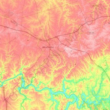
Name: Clark County topographic map, elevation, terrain.
Location: Clark County, Kentucky, 40391, United States (37.82181 -84.34897 38.11516 -83.96650)
Average elevation: 273 m
Minimum elevation: 171 m
Maximum elevation: 341 m
Make a donation
Gear up for your next adventure:
As an Amazon Associate, this site earns from qualifying purchases at no extra cost to you.
Other topographic maps
Click on a map to view its topography, its elevation and its terrain.
Make a donation
Gear up for your next adventure:
As an Amazon Associate, this site earns from qualifying purchases at no extra cost to you.
Make a donation
Gear up for your next adventure:
As an Amazon Associate, this site earns from qualifying purchases at no extra cost to you.
Make a donation
Gear up for your next adventure:
As an Amazon Associate, this site earns from qualifying purchases at no extra cost to you.