
Thornhill topographic map
Interactive map
Click on the map to display elevation.
About this map
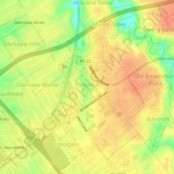
Name: Thornhill topographic map, elevation, terrain.
Location: Thornhill, Jefferson County, Kentucky, United States (38.28505 -85.62794 38.29115 -85.62304)
Average elevation: 180 m
Minimum elevation: 152 m
Maximum elevation: 194 m
Other topographic maps
Click on a map to view its topography, its elevation and its terrain.
Louisville
United States > Kentucky > Jefferson County
Louisville, Jefferson County, Kentucky, United States
Average elevation: 188 m
Moorland
United States > Kentucky > Jefferson County > Lyndon
Moorland, Lyndon, Jefferson County, Kentucky, 40242, United States
Average elevation: 193 m
Coldstream
United States > Kentucky > Jefferson County
Coldstream, Jefferson County, Kentucky, United States
Average elevation: 219 m
Prospect
United States > Kentucky > Jefferson County
Prospect, Jefferson County, Kentucky, United States
Average elevation: 166 m