
Salamanca topographic map
Interactive map
Click on the map to display elevation.
About this map
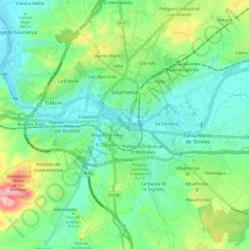
Name: Salamanca topographic map, elevation, terrain.
Location: Salamanca, Castile and León, Spain (40.91463 -5.73580 40.99319 -5.62262)
Average elevation: 812 m
Minimum elevation: 763 m
Maximum elevation: 935 m
The city is located at an altitude of 800 meters above sea level. The altitude of the municipality varies from 911 meters (Los Montalvos), in the southwest, and 763 meters in the last stretch in the municipality of the Tormes river.
Other topographic maps
Click on a map to view its topography, its elevation and its terrain.
San Cristóbal de Segovia
San Cristóbal de Segovia, Segovia, Castile and León, 40197, Spain
Average elevation: 1,060 m
Presa Vieja de Las Navas del Marques
Spain > Castile and León > Peguerinos
Presa Vieja de Las Navas del Marques, Peguerinos, Ávila, Castile and León, Spain
Average elevation: 1,496 m
Toroño
Spain > Castile and León > Porto
Toroño, Porto, Zamora, Castile and León, Spain
Average elevation: 1,495 m
Peñafiel
Peñafiel, Valladolid, Castile and León, 47300, Spain
Average elevation: 824 m
Río de la Mora
Spain > Castile and León > Navalacruz
Río de la Mora, Navalacruz, Ávila, Castile and León, Spain
Average elevation: 1,495 m
Milagros
Milagros, Burgos, Castile and León, 09460, Spain
Average elevation: 884 m
Mijares
Mijares, Ávila, Castile and León, 05461, Spain
Average elevation: 932 m
Sorriba del Esla
Spain > Castile and León > Cistierna
Sorriba del Esla, Cistierna, León, Castile and León, 24800, Spain
Average elevation: 1,021 m
Valdelugueros
Valdelugueros, León, Castile and León, 24845, Spain
Average elevation: 1,521 m
Sahechores de Rueda
Sahechores de Rueda, Cubillas de Rueda, León, Castile and León, Spain
Average elevation: 885 m
El Burgo Ranero
El Burgo Ranero, León, Castile and León, 24343, Spain
Average elevation: 878 m
Villamanín
Villamanín, León, Castile and León, Spain
Average elevation: 1,440 m
Cubillas de Rueda
Cubillas de Rueda, León, Castile and León, Spain
Average elevation: 972 m
Castroañe
Spain > Castile and León > Villaselán
Castroañe, Villaselán, León, Castile and León, 24344, Spain
Average elevation: 873 m
Villarmayor
Villarmayor, Salamanca, Castile and León, Spain
Average elevation: 804 m
Castillo de Alba
Spain > Castile and León > Losacino
Castillo de Alba, Losacino, Zamora, Castile and León, Spain
Average elevation: 745 m
Camino de Santiago
Spain > Castile and León > Zazuar
Camino de Santiago, Zazuar, Burgos, Castile and León, 09490, Spain
Average elevation: 848 m
Rágama
Spain > Castile and León > Rágama
Rágama, Salamanca, Castile and León, Spain
Average elevation: 845 m
Lanuza
Spain > Castile and León > Fresneda de la Sierra Tirón
Lanuza, Fresneda de la Sierra Tirón, Burgos, Castile and León, 26288, Spain
Average elevation: 1,215 m
El Arenal
Spain > Castile and León > Ávila > El Arenal
El Arenal, Ávila, Castile and León, Spain
Average elevation: 1,301 m
Membribe de la Sierra
Spain > Castile and León > Membribe de la Sierra
Membribe de la Sierra, Salamanca, Castile and León, Spain
Average elevation: 995 m
Osorno la Mayor
Spain > Castile and León > Osorno la Mayor
Osorno la Mayor, Palencia, Castile and León, 34460, Spain
Average elevation: 820 m
Los Altos
Los Altos, Burgos, Castile and León, 09551, Spain
Average elevation: 920 m
San Justo
Spain > Castile and León > San Justo
San Justo, Galende, Castile and León, Spain
Average elevation: 1,332 m
La Tala
Spain > Castile and León > La Tala
La Tala, Guijuelo, Castile and León, Spain
Average elevation: 946 m
Buenavista
Buenavista, Salamanca, Castile and León, Spain
Average elevation: 936 m
Manzanillo
Spain > Castile and León > Manzanillo
Manzanillo, Quintanilla de Onésimo, Castile and León, Spain
Average elevation: 825 m
Martínez
Spain > Castile and León > Martínez
Martínez, Valle Amblés y Sierra de Ávila, Ávila, Castile and León, Spain
Average elevation: 1,110 m
La Maya
Spain > Castile and León > La Maya
La Maya, Tierra de Alba, Salamanca, Castile and León, Spain
Average elevation: 850 m
Tejeda
Spain > Castile and León > Tejeda
Tejeda, Campo de Salamanca, Salamanca, Castile and León, 37607, Spain
Average elevation: 941 m
Valdorros
Spain > Castile and León > Valdorros
Valdorros, Arlanza, Burgos, Castile and León, 09320, Spain
Average elevation: 914 m
Aranda de Duero
Aranda de Duero, Burgos, Castile and León, Spain
Average elevation: 846 m
Contreras
Spain > Castile and León > Contreras
Contreras, Sierra de la Demanda, Burgos, Castile and León, Spain
Average elevation: 1,089 m
Santo Tomé del Puerto
Santo Tomé del Puerto, Segovia, Castile and León, 40590, Spain
Average elevation: 1,347 m