Geolocate

Fall River topographic map

Click on the map to display elevation.

About this map

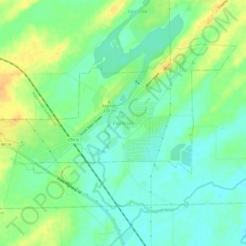
Name: Fall River topographic map, elevation, terrain.

Location: Fall River, Columbia County, Wisconsin, United States (43.36443 -89.06511 43.40443 -89.02511)

Average elevation: 266 m

Minimum elevation: 253 m

Maximum elevation: 285 m

Other topographic maps

Click on a map to view its topography, its elevation and its terrain.

Lodi

United States > Wisconsin > Columbia County

Average elevation: 269 m

Poynette

United States > Wisconsin > Columbia County

Average elevation: 269 m

Wyocena

United States > Wisconsin > Columbia County

Average elevation: 255 m

Friesland

United States > Wisconsin > Columbia County

Average elevation: 305 m

Cambria

United States > Wisconsin > Columbia County

Average elevation: 282 m

Doylestown

United States > Wisconsin > Columbia County

Average elevation: 290 m

Fall River

United States > Wisconsin > Columbia County

Average elevation: 266 m

Portage

United States > Wisconsin > Columbia County

Average elevation: 244 m

Columbus

United States > Wisconsin > Columbia County

Average elevation: 258 m

Gear up for your next adventure:

📷Outdoor Action Camera - Capture high-elevation views and rugged adventures
🥾Light Trekking Boots - Supportive boots for multi-day treks
🧴Waterproofing Spray - Restore the DWR coating on jackets and tents
Camping Coffee Maker - Brew fresh coffee anywhere on the topographic map
🔦LED Headlamp - Hands-free lighting for early morning starts or late finishes

As an Amazon Associate, this site earns from qualifying purchases at no extra cost to you.