Geolocate

Doylestown topographic map

Click on the map to display elevation.

About this map

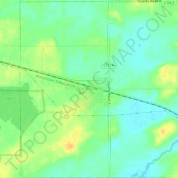
Name: Doylestown topographic map, elevation, terrain.

Location: Doylestown, Columbia County, Wisconsin, 53928, United States (43.41298 -89.16580 43.44224 -89.12549)

Average elevation: 290 m

Minimum elevation: 278 m

Maximum elevation: 307 m

Other topographic maps

Click on a map to view its topography, its elevation and its terrain.

Fall River

United States > Wisconsin > Columbia County

Average elevation: 266 m

Dekorra

United States > Wisconsin > Columbia County

Average elevation: 259 m

Englewood

United States > Wisconsin > Columbia County

Average elevation: 276 m

Gear up for your next adventure:

👟Sport Hiking Sandals - Breathable footwear for water crossings and camp rest
🥾Trail Hiking Socks - Comfortable socks to prevent blisters and fatigue
🦯Trekking Poles - Reduced impact on joints for steep topographic climbs
💧Filtered Water Bottle - Safe drinking water on the go
Camping Coffee Maker - Brew fresh coffee anywhere on the topographic map

As an Amazon Associate, this site earns from qualifying purchases at no extra cost to you.