Geolocate

Columbus topographic map

Click on the map to display elevation.

About this map

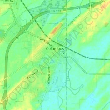
Name: Columbus topographic map, elevation, terrain.

Location: Columbus, Columbia County, Wisconsin, 53925, United States (43.31277 -89.04895 43.36006 -89.00666)

Average elevation: 258 m

Minimum elevation: 247 m

Maximum elevation: 276 m

Other topographic maps

Click on a map to view its topography, its elevation and its terrain.

Fall River

United States > Wisconsin > Columbia County

Average elevation: 266 m

Dekorra

United States > Wisconsin > Columbia County

Average elevation: 259 m

Englewood

United States > Wisconsin > Columbia County

Average elevation: 276 m

Gear up for your next adventure:

💡Solar Camping Lamp - Eco-friendly lighting for campsites
🗺️Topographic Maps - Detailed maps to explore trails, mountains, and wilderness areas
🪑Insulated Seat Pad - Protect your seat from cold rocks and wet logs
🥾Trekking Poles - Adjustable trekking poles to reduce knee stress and improve stability
🧴Insect Repellent - Protect yourself from bugs during outdoor adventures

As an Amazon Associate, this site earns from qualifying purchases at no extra cost to you.