Geolocate

Poynette topographic map

Click on the map to display elevation.

About this map

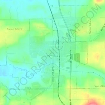
Name: Poynette topographic map, elevation, terrain.

Location: Poynette, Columbia County, Wisconsin, United States (43.37741 -89.43270 43.40691 -89.38766)

Average elevation: 269 m

Minimum elevation: 244 m

Maximum elevation: 319 m

Other topographic maps

Click on a map to view its topography, its elevation and its terrain.

Fall River

United States > Wisconsin > Columbia County

Average elevation: 266 m

Dekorra

United States > Wisconsin > Columbia County

Average elevation: 259 m

Englewood

United States > Wisconsin > Columbia County

Average elevation: 276 m

Gear up for your next adventure:

👟Trail Running Shoes - Agile footwear for fast-paced topographic exploration
🥾Hiking Gaiters - Protect legs and shoes from mud, snow, and debris
🦟Insect Repellent - Keep mosquitoes and black flies away in wooded areas
🧥Waterproof Pants - Keep dry during rainy hiking conditions
🦯Trekking Poles - Reduced impact on joints for steep topographic climbs

As an Amazon Associate, this site earns from qualifying purchases at no extra cost to you.